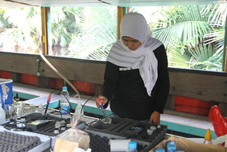
Dr. Anshari’s student, Ms. A. Putri, measures pH and conductivity of water samples on the boat during the June 2013 sample campaign (photo courtesy of Dr. Anshari).
|
The tropical peat lands of Borneo and the rivers that flow through these landscapes are important for supplying natural goods, maintaining livelihoods, conserving biodiversity, and affecting climate. Peat forests and associated rivers provide timber, freshwater fish, and other natural products. Because tropical peats are only stable under water-logged environment, the climate must be sufficiently wet, or peat will not accumulate. Biodiversity also flourishes under a wet climate. Therefore, there is a strong link among sustainability of livelihoods, biodiversity, and the stability of climates. Increasing uses and disturbances of these peat forests and rivers induce degradation of tropical peat domes (including drainage), which leads to an increase of carbon dioxide emissions through the atmosphere and lateral export through rivers to the ocean. As a result, peat degradation not only depletes natural resources but also affects climate stability.
This project aims to link lateral carbon exports by rivers to characterization of peat degradation from satellite data and field measurements. The researchers will contrast rivers in North and South Borneo (i.e., the Belait River in Brunei Darussalam and the Mempawah and the Lower Kapuas Kecil River in West Kalimantan Province, Indonesia). Expected outputs of this joint research project include thematic maps of peat dome degradation and DOC fluxes from the rivers being studied. Although it has been recognized to be important, the fluvial export of carbon from tropical peatlands has rarely been assessed. In this project, sensors will be developed to evaluate DOC fluxes from these rivers to South China Sea with the aim of providing the first accurate measurement of fluvial carbon fluxes from tropical peat lands. This project also aims to increase awareness and knowledge of tropical peat lands, their role, and the impact of their degradation. For this purpose, a reference book and extension materials will be developed and disseminated in both English and Bahasa Indonesia. A multi-stakeholder workshop on the relation between tropical peat lands and climate change will be organized, and a website on climates and tropical peat lands will be constructed.
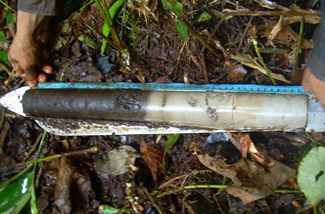
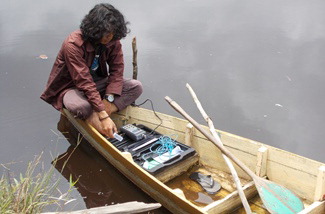
The research team’s field activities included gathering water and peat samples in situ, measuring peat depth, pH, and conductivity of water in the target rivers. Thanks to PEER funding, they were also able to acquire a portable gas analyzer to measure CO2 emissions from peat soils, as well as other gases. Multiple graduate and undergraduate students have developed their ongoing research and completed their theses during this project as part of their studies. One of the researchers on the team, Dr. Evi Gusmayanti, was awarded an additional research grant from the Indonesian Ministry of Research, Technology and Higher Education to continue and expand her study of carbon flux from oil palm on peats, a three-year project that involved undergraduates and one research assistant. During the PEER project, Dr. Anshari and his colleagues also developed and introduced a new course on peatland ecosystems and conversation, designed to introduce students to local and global perspectives on how to manage tropical peatlands and give them hands-on research experience.
Dr. Anshari and other team members presented their findings to the American Geophysical Union Joint Assembly conference, a seminar on tropical peatlands at the Oregon State University, and a local conference in Indonesia. The team also communicated results of the PEER findings to NGOs and governments, in particular on peat distribution and peat properties in West Kalimantan Province to Badan Restorasi Gambut (Peatland Restoration Agency), allowing the institution to generate a map for a peat restoration program. The researchers also conducted peat training for two companies that operate oil palm plantations, PT Agrolestari Mandiri, and PT Paramita Internusa Pratama.
PublicationsGusti Z. Anshari, Evi Gusmayanti, M. Afifudin, Monika Ruwaimana, Lauren Hendricks, Daniel G. Gavin. 2022. Carbon loss from a deforested and drained tropical peatland over four years as assessed from peat stratigraphy.
Catena 208: 105719.
https://doi.org/10.1016/j.catena.2021.105719 Tri T.A. Putri, L. Syaufina, G. Anshari. 2016. Emisi Karbon Dioksida (CO
2) Rizosfer dan Non Rizosfer dari Perkebunan Kelapa Sawit (
Elaeis guineensis) pada Lahan Gambut Dangkal [Rhizospheric and Non-rhizospheric Carbon Dioxide (CO
2) Emissions from Oil Palm (
Elaeis guineensis) Plantation on Shallow Peat].
Jurnal Tanah dan Iklim 40(1): 43-50.
Muhammad Nuriman, Gunawan Djajakirana, Darmawan, Gusti Z. Anshari. 2015. Metode Alternatif Memperkirakan Konsentrasi Karbon Organik Terlarut dalam Air Saluran Drainase dan Tanah Gambut [An Alternative Method for Estimating Dissolved Organic Carbon (DOC) Concentration in Drainage Canal and Peat Pore Water].
Jurnal Tanah dan Iklim 39(1): 1-8.
Evi Gusmayanti, Gusti Z. Anshari, M. Afifudin. 2014. Estimasi stok dan emisi karbon serta strategi penggunaan lahan dalam mitigasi perubahan iklim di kubah gambut Rasau Jaya, Kalimantan Barat [Estimation of carbon stock and emission, and land-use strategy for climate change mitigation in Rasau Jaya Peatdome, West Kalimantan. Presented at the Seminar Nasional dan Rapat Tahunan Bidang MIPA 2014 | SEMIRATA.