|
Cycle 4 (2015 Deadline)
Lidar remote sensing of Brazilian Amazon forests: Analysis of forest biomass, forest degradation, and secondary regrowth
PI: Jean Ometto (jean.ometto@inpe.br), Instituto Nacional de Pesquisas Espaciais (INPE)
U.S. Partner: Michael Keller, USDA - Forest Service
Project Dates: November 2015 - March 2021
Open Data Repository
Project Overview
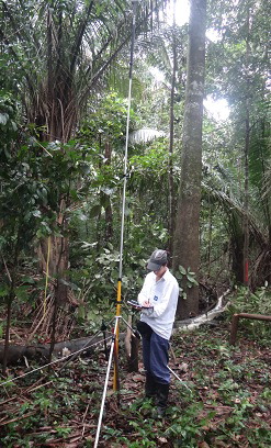 | | Georeferencing of field plots. |
Recently, the Earth System Science Center (CCST) at INPE received substantial funding from the Amazon Fund-BNDES to improve knowledge of land use change and carbon budgets in the Brazilian Amazon. As part of this project, INPE plans to contract LIDAR (light detection and ranging or laser scanning) remote sensing flights to acquire forest structure information over the Amazon that can be used to improve our knowledge of forest biomass. These data will substantially overcome the current limitations of insufficient and biased sampling of the Brazilian Amazon forest and provide the first large-scale, statistically balanced characterization of forest carbon stocks across the Amazon region. The experimental design will not only estimate carbon stocks across the region but also identify the proportions of forest that are currently secondary or degraded and thus are potentially large carbon sinks in the future. The LIDAR data calibrated by a network of ground-based forest inventories will be used to achieve three objectives:
1. Reduce the uncertainty in the quantification of the above-ground carbon stocks of the forests of the Brazilian Amazon
2. Provide improved estimates of carbon emissions from deforestation and avoided carbon loss from reducing deforestation policies in the Brazilian Amazon region
3. Improve our ability to predict future carbon fluxes in the Brazilian Amazon by quantifying the current biomass status of secondary and degraded forests.
This project should improve the estimation of carbon emissions from deforestation in the Brazilian Amazon and construct a sound basis for future emissions scenarios, considering different options of land use and land cover change. Several strategies, policies, and compensation mechanisms have been proposed to minimize the impact of human actions on the natural forest. Among those, effective implementation of REDD+, soy and beef moratoria, and establishment of conservation units can benefit from better calculation of the balance between carbon emission by deforestation and forest degradation, and uptake, by secondary vegetation and mature forest growth. Through capacity building activities, this project will train young researchers in LIDAR estimates of biomass, statistical biomass modeling and mapping, and emissions modeling. The data gathered will be a resource for the Brazilian Ministry of Science, Technology, and Innovation to produce the National Inventories on GHG emissions. The Brazilian Earth System Model, currently under development at INPE and associated universities and research institutes, is also an obvious client of the planned database. Finally, through its leadership in forest monitoring activities, Brazil has the potential to share its knowledge and technologies with neighboring countries, especially those of the Amazonian Cooperation Treaty Organization.
Final Summary of Project Activities During the final year on this project, which ended on March 31, 2021, Dr. Ometto and his team focused on publishing their results and performing extra analysis on lidar data sets and satellite imagery. They expanded the study to include the region bordering the Amazon, entering the Cerrado area in cooperation with another collaborative scientific project. Despite the COVID-19 pandemic situation in Brazil and respecting all security protocols, in late 2020 the researchers were able to carry out field data collection activities in the Amazon and transition areas with the Cerrado as planned. The information collected will be part of a future scientific publication. During this pandemic period, they also took the opportunity to write scientific articles and organize online meetings to discuss partnerships and contributions to other publications. Plans for in-person events, however, were seriously impacted, and no such events could be organized.
The results from this project include 11 published papers so far, as well as a large collection of data available on Zenodo, an Open Access digital repository where researchers from any field of science can share their findings: https://zenodo.org/record/4557390#.YRqi7ohKgn9. In addition, in terms of potential policy impacts, Dr. Ometto reports that the biomass map of the Amazon region produced with the help of PEER funding has been incorporated in several efforts in Brazil beyond the scientific publications mentioned. The PEER team communicated with the Brazilian Ministry of Science and Technology to provide inputs to the Brazilian National Communication to the United Nations Framework Convention on Climate Change. The biomass map was also incorporated into the Emission Model developed by the National institute for Space Research (INPE) and is included in other initiatives like the MapBiomas. Although PEER support has ended, the PI and his colleague plan to continue collaborating with their counterparts in the United States and elsewhere to advance their studies of Amazon forest dynamic, structure, and biomass content, including field recalibration, interpolation, and comparison to other databases (e.g., NASA’s Global Ecosystem Dynamics Investigation) and remote platforms.
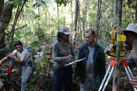 | 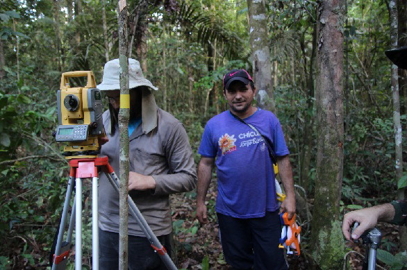 | | The team conducts extensive data collection activities in the Amazon (Photos courtesy of Dr. Ometto). |
Recent Publications
- Dalagnol, R., Wagner, F.H., Galvão, L.S. et al. 2021. Large-scale variations in the dynamics of Amazon forest canopy gaps from airborne lidar data and opportunities for tree mortality estimates. Sci Rep 11, 1388 (2021). https://doi.org/10.1038/s41598-020-80809-w
- Vieira, Rita Marcia da Silva Pinto, et al. 2021. Land degradation mapping in the MATOPIBA region (Brazil) using remote sensing data and decision-tree analysis. Science of the Total Environment 782 (2021): 146900, https://doi.org/10.1016/j.scitotenv.2021.146900
- Assis , T.O., A.P.D. Aguiar, C. von Randow, D.M.P. Gomes, J.N. Kury, J. Ometto, and C.A. Nobre. 2020. CO2 emissions from forest degradation in Brazilian Amazonia. Environ. Res. Lett., in press https://doi.org/10.1088/1748-9326/ab9cfc
- Tejada, G., E.B. Görgens, A. Ovando, et al. 2020. Mapping data gaps to estimate biomass across Brazilian Amazon forests. For. Ecosyst. 7, 25. https://doi.org/10.1186/s40663-020-00228-1
- Bispo, P.C.; P. Rodríguez-Veiga, B. Zimbres, S. do Couto de Miranda, C. Henrique Giusti Cezare, S. Fleming, F. Baldacchino, V. Louis, D. Rains, M. Garcia, F. Del Bon Espírito-Santo, I. Roitman, A.M. Pacheco-Pascagaza, Y. Gou, J. Roberts, K. Barrett, L.G. Ferreira, J.Z. Shimbo, A. Alencar, M. Bustamante, I.H. Woodhouse, E. Eyji Sano, J.P. Ometto, K. Tansey, and H. Balzter. 2020. Woody Aboveground Biomass Mapping of the Brazilian Savanna with a Multi-Sensor and Machine Learning Approach. Remote Sens. 2020, 12(17), 2685; https://doi.org/10.3390/rs12172685
- Erone Ghizoni Dos Santos, Yosio Edemir Shimabukuro, Yhasmin Mendes De Moura, Fabio Guimarães Gonçalves, Anderson Jorge, Kaio Alan Gasparini, Egidio Arai, Valdete Duarte, and Jean Pierre Ometto. 2019. Multi-scale approach to estimating aboveground biomass in the Brazilian Amazon using Landsat and LiDAR data, International Journal of Remote Sensing, 40:22, 8635-8645, https://doi.org/10.1080/2150704X.2019.1619955
- Nascimento, N., T.A.P. West, L. Biber-Freudenberger, E.R. Sousa-Neto, J. Ometto, and J. Börner. 2019. A Bayesian network approach to modelling land-use decisions under environmental policy incentives in the Brazilian Amazon. Journal of Land Use Science https://doi.org/10.1080/1747423X.2019.1709223
- Almeida, C.T., L.S. Galvão, L.E.O.C. Aragão, J.P.H.B Ometto, A.D. Jacon, F.R.S. Pereira, L.Y. Sato, A.P. Lopes, P.M.L.A. Graça, C.V.J. Silva, J. Ferreira-Ferreira, and M. Longo. 2019. Combining LiDAR and hyperspectral data for aboveground biomass modeling in the Brazilian Amazon using different regression algorithms. Remote Sensing of Environment 232, 111323. https://doi.org/10.1016/j.rse.2019.111323
- Pereira, I., H.M. Nascimento, B.M. Cicari, M. Disney, E. Delucia, T.F. Domingues, B. Kruijt, D. Lapola, P. Meir, R. Norby, J. Ometto, C. Quesada, A. Rammig, and F. Hofhansl. 2019. Performance of Laser-Based Electronic Devices for Structural Analysis of Amazonian Terra-Firme Forests. Remote Sensing 11(5), 510. https://doi.org/10.3390/rs11050510
- Görgens, E.B., A.Z. Motta, M. Assis, M.N. Nunes, T. Jackson, D. Coomes, J. Rosette, L.E.O.C. Aragão, and J.P. Ometto. 2019. The giant trees of the Amazon basin. Frontiers in Ecology and the Environment 17(7), 373-374. https://doi.org/10.1002/fee.2085
- Tejada, G., E.B. Görgens, F.D. Espírito-Santo, R.Z. Cantinho, and J.P. Ometto. 2019. Evaluating spatial coverage of data on the aboveground biomass in undisturbed forests in the Brazilian Amazon. Carbon Balance and Management 14, 11. https://doi.org/10.1186/s13021-019-0126-8
Back to PEER Cycle 4 Grant Recipients
|


