|
Cycle 4 (2015 Deadline)
Can drought and flood hazard be skillfully assessed at fine spatial resolution from combining constrained streams of observed, remotely sensed and model predicted data in Sri Lanka and the Maldives?
PI: Piyasena Wickramagamage (pwickramagamage@gmail.com), Foundation for Environment, Climate and Technology
U.S. Partner: Randall Koster, NASA Goddard Space Flight Center
Project Dates: October 2016 - March 2019
Project Overview
Studies of the utility of drought and flood hazard indices indicate that a thorough depiction of hazard risks requires combined analysis of the co-variation of multiple meteorological and terrestrial variables such as rainfall, runoff, and soil moisture conditions. Current hazard estimations do not objectively combine separate indicators into an overall assessment of hazard risks and the impacts of climate variability. In countries such as Sri Lanka and Maldives there are severe constraints on real-time data availability. Such shortfalls can impair the reliability of and access to real-time hazard assessments if based entirely on one source of data. Freely available data from satellite estimates for soil moisture and prediction products from NASA and NOAA can be very useful, and field testing their accuracy in tropical locations should also help in validating them. This project will involve expanding, testing, and implementing a hazard analysis framework for combining multiple terrestrial indicators to estimate the probability of drought and floods. This work builds on studies of hazards, climate and land surface modeling, and disasters previously completed by the research team, some of it in cooperation with the U.S. Government-supported partner.
Sri Lanka is densely populated with high spatial variability in climate and high vulnerability to disasters. Recent droughts have led to drops in economic growth and losses in livelihoods. Floods are a leading causes of loss in life from natural disasters of the population of 21 million. In 2014, a severe drought emergency up to September was followed by flood emergency from till December. The Maldives is a country made up of almost 1,200 small islands, and their isolated location, size, and storage limitations leave the population of 350,000 vulnerable to drought risk. In recent years, there has been more frequent drought and increasing groundwater contamination. Although, climate variability and its impacts on hazards are of critical importance in both countries, the scientific understanding is not equal to the risk, and available information is not adequately accessed. Major policy decisions and large projects related to hazard are being undertaken without a robust basis in current science. The development-related objective of this project is to build integrated assessment, monitoring, and prediction capabilities for natural hazards that will be useful for decision makers. In Sri Lanka, the team will instrument two sites for measuring soil moisture, river levels, and ground water and provide water scarcity assessments to the Water Management Services Panel, building on a weekly climate advisory already provided to this panel. In the Maldives, the focus will be on drought and groundwater assessments, which will be conducted in liason with the Meteorological and Water Supply Services, hydrologists, and instrumentation specialists. The project team will undertake field measurements of meteorology, soil moisture, and the groundwater lens in two regions.
Final Summary of Project ActivitiesThe project goal was to develop operational drought, flood, and landslide hazard assessments using climate, terrestrial and societal information, and to assess drought and flood risk reliably in Maldives and Sri Lanka.In view of this, the team was able to obtain and set up data management systems for diagnosis or past disasters and has examined six significant past drought and flood disasters in Maldives and Sri Lanka and analyzed the role of climate and other factors. The team also set up monitoring systems for weather using 10 ground stations in Maldives and Sri Lanka and was able to provide engagement and training on them. They set up tools for access to satellite data for Sri Lanka and the Maldives in real time. This data was cross checked with ground observed data. The team also set up three instruments for monitoring soil moisture in Maldives and Sri Lanka. These systems culminated in a system that compiles and digests the weather and climate predictions for Maldives and Sri Lanka. The results of which are now being provided to stakeholders and collaborators, along with the public on a weekly and monthly time-frame.
Through case studies and the monitoring systems, the team undertn a detailed study of information to support decision making for - Island Water Budgeting
- Flood Prediction without significant observation
- Drought Monitoring based on satellite data
- Air Quality impacts in an agricultural area affected by Industry
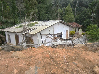 | 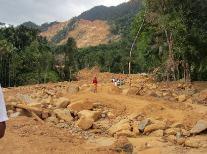 | 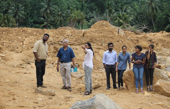 | | Heavy rainfalls resulted in devastating landslides in Sri Lanka. The team's models had predicted the weather event and the team visited the location afterwards to meet with local officials (photo credit: Dr. Wickramagamage). |
Project Website: http://disaster.lk/
Back to PEER Cycle 4 Grant Recipients
|


