Partnerships for enhanced engagement in research (PEER) SCIENCE Cycle 1 (2011 Deadline)
Reducing soil loss through effective soil and water conservation practices using hydrologic considerations and farmers’ participation in the Blue Nile Basin
PI: Seifu Tilahun, Bahir Dar University
US Partner: Christopher Barrett, Cornell University
Project Dates: May 2012 - February 2017
Project Overview
Soil erosion decreases food production and hampers poverty reduction efforts in the highlands of eastern Africa. Although intensive efforts have been underway both to reduce sediment production and to halt land degradation since the 1980s, erosion continues unabated and the already low crop yields are decreasing even further. Shallow soils are becoming shallower and are often abandoned, and gullies are swallowing up productive cropland. Finally, some of the lost soil fills up reservoirs and silts up downstream irrigation canals. Current measures to reduce soil loss are ineffective, and new approaches that both consider the hydrology of the whole landscape (instead of the current plot based erosion research) and use traditional farmer’s knowledge for locating erosion control practices are required. The goal of the proposed research is to develop appropriate watershed and farmer-based erosion control practices for the Ethiopian highlands in order to replace the well minded imported and inappropriate technologies from foreign donors.
A video summary of Dr. Tilahun's project and efforts to combat soil loss in the Blue Nile Basin.
These researchers will instrument the Debre Mawi (5.27km2) and Bir (64km2) watersheds in the headwaters of Blue Nile and to continue monitoring another instrumented by the International Water Management Institute (IWMI), the Mizewa watershed (27km2). Their efforts will be aimed at identifying erosion hotspots by measuring spatially distributed runoff and soil loss (from periodically saturated areas in the valley bottoms and areas with exposed subsoil that are severely degraded) and by participatory watershed methods approach and sediment tracers. They will also study the relationship between nutrient loss and soil loss by measuring soil nutrients (N, P, K, Mg, and Ca). Perched water table levels will be measured in the Bir watershed (~64km2) to identify saturated areas. Gullies will be monitored through areal and satellite images in addition to field measurement in the Bir and Debre Mawi watersheds. By locating the hotspot areas within the watershed, they will propose effective conservation practices. A simple physically-based hydrology model will be applied to locate the practices on the vulnerable areas. Their predictions will be compared with farmers’ knowledge including the location of the traditional practices. Finally, practices will be designed with the participation of farmers. Within the project period and beyond, some of the proposed practices will be installed with the farmers’ help in the Debre Mawi and monitored after the project. This research project will be carried out by the School of Civil and Water Resource Engineering as part of the newly implemented PhD program and an existing master’s graduate program on hydrology in close cooperation with faculty and students of an NSF IGERT program at Cornell. Most importantly, the international partnership will train future scientists and managers in managing the soil and water resources in Ethiopia.
Overall Summary of Activities
This project showed that current massive soil conservation practices on the highlands of Blue Nile Basin Ethiopia have an immediate impact on reducing erosion and soil loss. However, responsible organizations including government and NGOs should also focus on best management practices at bottomlands where gullies are expanding and not just to the current massive practices on the steep hill slopes. Moreover, the team showed that gullies as deep as 15 m deliver the majority of the sediment to the rivers and swallow valuable grass and cultivated lands. Despite the obvious and enormous effect of gullies on sediment transport, large-scale government-led conservation mobilization works do not target them as hotspots that need fixing. One of the reasons might be that these gullies are difficult and expensive to rehabilitate, and are seen by the communities as a punishment from God for being against his will and, as such, any efforts to rehabilitate them will be in vain. In one of the experimental watersheds, this project team was able to rehabilitate five gullies with the aid of the community and thereby change the perception of farmers on their ability to stop gully formation.
The research work in Bir watershed had an impact on the communities of the areas and beyond as communities were not expecting any benefit from the rehabilitation of gullies. The benefit from the gully was fodder for livestock for fattening and milking and these benefits to farmers were the major mechanism to mobilize the community to work on gully rehabilitation activities. To pass the message of our successes beyond the local communities, a workshop was conducted in October 2014 and 22 research papers were presented. Presentations included land use change, hydrological processes, erosion rates, flow restricting pan formations, gully erosion, evaluation of conservations practices, and conservation of gullies. All 11 PhD students and MSc students associated with PEER Science project presented their findings. During the workshop three briefing notes and one book of abstracts were distributed to the participants.
Moreover, one documentary film was produced. The video will be useful as a means to translate research results to policy makers and awareness creation amongst those dedicated to planning, implementing and maintaining soil and water conservation practices. The video can also be use at an internationally to create awareness of the soil and conservation problems and challenges in Ethiopia and might even prevent misdirected efforts of future donors.
This project received supplemental PEER funding to conduct research dissemination workshops and field visits to showcase to farmers, low and high level SWC practitioners and policy makers that:
To reduce storm runoff and soil loss from a catchment, SWC measures should be tailored to specific field conditions by considering the hydrology (such as ground water table pattern), topography and soil types. Infiltration ditches were found effective on the hillsides whereas on the saturated bottomlands, such structures concentrate runoff, initiated gullies and caused more erosion.
Including gully treatment and stabilization as an important component of the large soil and water conservation measures can help to reduce sediment loads in major Ethiopian rivers such as the Blue Nile basin.
Treatment of shallow gullies is necessary. Findings indicated different priorities and issues between gullies having a depth greater than 3m and less than 3m. In the deeper gullies, a huge amount of labor and cost was required for treatment as compared with shallow gullies. The shallow gully treatment was completely effective unlike the collapse of structures in the deeper gully.
The cost comparison was done to determine how much it costs for the head treatment regarding adding stone rip rap at the head with the currently used loose stone and gabion check dams. The head treatment is low cost ($9/m2) and technically can be implemented by the local farmers. Whereas loose stone and gabion check dams costs $69 and $120 respectively.
In collaboration with Bahir Dar University, the Bureau of Agriculture of Amhara Region took an initiative to implement these research outputs at the farmers’ fields. Because of this, farmers, development agents, district level, zonal, and regional natural resource management officials participated in an upscaling workshop in Finote-Selam. After the completion of the workshop, four regions in the Amhara Region implemented the recommended measures from project research findings in their watersheds and invited guests to observe their efforts. The Bureau of Agriculture is now using lessons learned from the pilot districts as part of the regional natural resource management plans.
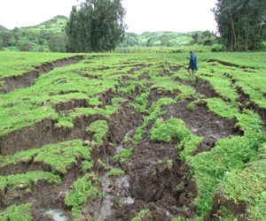
The gully rehabilitation demonstration shows improvement through community participation in physical and biological conservation. (Photo courtesy Dr. Tilahun).
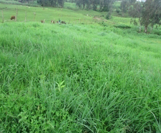
At the same time gully erosion expansion is severe in the control area (Photo courtesy Dr. Tilahun).