Development of a Framework for Probabilistic Seismic
Hazard Maps for Pakistan
Scott Olson and Youssef Hashash, University of Illinois at Urbana-Champaign
Irshad Ahmad and Akhtar Naeem Khan, NWFP University of Engineering and Technology, Peshawar
Pakistani Funding (HEC): $130,000
US Funding (USAID): $174,705
Project Dates on US Side: February 1, 2007 - October 31, 2011
Project Overview
Given Pakistan’s seismo-tectonic setting, the 2005 Kashmir earthquake is not a one-time event, but part of a sequence of earthquakes that have happened in the past and will happen again in the future. More importantly, the earthquake highlighted the severe limitations of existing seismic hazard characterization in Pakistan. Several efforts by the Pakistan Meteorological Department and collaborations with the U.S. Geologic Survey as well as groups in Japan and Norway are under way to better define seismicity in Pakistan through various mapping, instrumentation, and data collection activities. These groups will use the collected data to generate region-specific attenuation relationships and ground motion estimates. However, an important gap remained in these efforts at the interface between seismology and earthquake engineering. That is, a need existed to develop appropriate factors to account for local soil response and topographic effects. These “site response” factors are a common component in design codes worldwide to translate ground motions developed by seismic hazard mapping efforts for use by design engineers. Perhaps more importantly, there is a need to train current and future Pakistani engineers to use the seismic hazard mapping tools and products that others are producing. This project focused on building Pakistani capacity in the area of seismic hazard characterization for engineering applications and for developing loss scenarios and emergency response plans.
Major Results
- Developed two methods to estimate the characteristics rates of faults in northwestern Pakistan
- Engaged a PhD student to work on seismic hazard analysis and study seismic slope stability analysis
- Conducted a workshop on seismic hazard analysis that attracted 50 participants from universities, government agencies, and private engineering firms across Pakistan
- Delivered a graduate seismic hazard course at NWFP UET, including projects allowing students to apply deterministic and probabilistic analyses to specific assigned sites
- Generated a peak ground acceleration (PGA) contour map for the 2005 Kashmir earthquake using deterministic seismic hazard analysis and compared that with previously created PGA maps to verify the procedures used
Quarterly Update
The project received a no-cost extension through October 31, 2011. During the last few months, this research team continued working on generating hazard maps for northwestern Pakistan, preparing the final report, and submitting journal papers regarding seismic hazard analysis.
Progress Report Summaries
Show all progress summaries | Hide progress summaries
2010 Show summary || Hide summary
During 2010, the researchers on this project developed two methods to estimate characteristic rates of faults in North Western Pakistan. They generated the PGA contour map for 2005 Kashmir, Pakistan earthquake using the DSHA and compared that with the recorded PGA to verify the procedures. The team produced seismic hazard maps for NW Pakistan and a paper regarding probabilistic seismic hazard analysis in NW Pakistan was accepted to the 5th International Conference on Earthquake Geotechnical Engineering. One PhD student on the U.S. side engaged in working on the seismic hazard analysis in NW Pakistan as well as the study of seismic slope stability analysis. A new approach to the seismic slope stability analysis that incorporates the vertical ground acceleration, topographic effect, and bond break effect was proposed by the team.
2009 Show summary || Hide summary
In 2009, the graduate seismic hazard course was once again presented at NWFP UET, with students being assigned sites for deterministic and probabilistic analyses. Many of the specific research tasks in the project were completed. Two papers were completed and more were expected as the seismic hazard and topographic studies have been completed. However, the purchase and installation of the seismic instrumentation was delayed repeatedly due to the complex requirements of NWFP UET's procurement system. By October 2009, geophysical and geotechnical testing was under way at the site to characterize the soil properties, and preparatory work was still in progress as of June 2010.
2008 Show summary || Hide summary
The researchers planned a workshop for practitioners in seismic hazard analysis, which was to have been presented in January 2008. It had to be postponed due to security conditions but was ultimately presented at HEC headquarters in Islamabad August 24-25, 2008. The workshop attracted 50 participants from universities, government agencies, and private engineering firms across Pakistan. Dr. Hashash participated in person while Dr. Olson delivered his lectures via video conferencing. Meanwhile, a site was selected at UET Mardan for installation of the field testing equipment. Initial site characterization studies were in progress as of December 2008, and discussions were under way with equipment vendors and installation firms. The site was expected to be used as a field laboratory to teach students and practitioners about the importance of field work for seismic hazard analysis and earthquake engineering, as well as to obtain preliminary data on topographic effects.
2007 Show summary || Hide summary
After the project began in early 2007, the US and Pakistani partners worked closely to develop a semester-long course on Engineering Seismology and Seismic Hazard Analysis, which was offered for the first time at NWFP UET in the fall 2007 semester. Many of the course lectures were delivered remotely by the US partners on the project. In addition to developing the course curriculum and materials, the US team also collected and reviewed relevant literature on seismicity in Pakistan and worked on adapting two seismic hazard analysis software packages for use with Pakistani data. Meanwhile, the Pakistani partners collected literature, maps, and other data and worked to identify potential sites for conducting field investigations and installing seismic instrumentation.
|
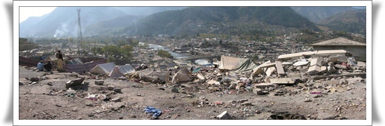
A view of the devastation left after the October 2005 earthquake.
|
Back to Pakistan-US Cooperative Program in Earthquake-Related Research Main Page


