The researchers analyzed several climate extreme indices for Myanmar and Thailand using observations for daily maximum and minimum temperatures and total daily rainfall for the 1983–2012 period. After investigating changes in forest area and carbon stocks over a shorter period, they estimated the effects of climate extremes on gross primary productivity of the forest ecosystem. The team then applied the data to a Vegetation Condition Index (VCI) to investigate the forest conditions due to meteorological drought, and used the Standardized Precipitation Index (SPI) to identify the drought years and non-drought years during the 35-year study period. Based on this analysis, they selected the years 2010 (driest) and 2011 (wettest) to investigate how the tropical dry forest area of Myanmar responded. Their preliminary results suggested VCI and SPI are well correlated and could provide near real-time information of drought monitoring on vegetation stress, and VCI could give a future indicator of occurrence and severity of drought-affected areas.
The team also undertook a vulnerability assessment around mangrove reserves in Ayeyarwady Delta Coastal Zone. The region has a high chance of exposure to climate extremes, exemplified by Cyclone Nagi in 2008, as well as low adaptive capacity in the communities near the mangrove reserves, based on household surveys. They also found information on the mangrove ecosystem’s status, including the biomass content, species composition and its vulnerability to climate change, is useful for the ECD’s management of this specific ecosystem, and to support the decision-making process.
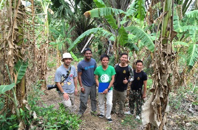
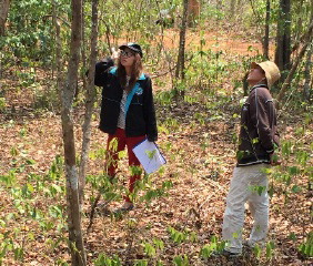
The project team applied forest classification methodology in Lampang Province, Thailand, a region that is home to the most common types of forests in the country, including varieties of both deciduous and evergreen forests. Based on their preliminary classification, the team conducted a field survey in collaboration with the Royal Forest Department of Thailand, which was incorporated into the final forest classification and map. Using freely available data from Landsat and Sentinel-2, the project team worked on a Google Earth Engine (GEE)-based mangrove forest classification. In field survey sampling, team members also tested the use of unmanned aerial vehicles.
This project work also involved creating and disseminating new climate change and remote sensing modules that are based on freely available moderate resolution satellite and climate data. Towards the end of the project period, the PI’s university made an initial agreement to help set up basic remote sensing capabilities and a GIS laboratory at the Environmental Conservation Department (ECD) of the Ministry of Natural Resources and Environmental Conservation (MONREC) of Myanmar, including consultation and brainstorming on the design, basic infrastructure, activity development, and basic GIS training courses at ECD. Meanwhile, ECD has sent four more new students to study at JGSEE.
The team developed methods to correct terrain effect from satellite imagery used for national scale forest mapping. The Royal Forest Department of Thailand is considering implementing this method in their future forest mapping efforts. Parts of the results of this project on the relationship between satellite-derived Normalized Difference Vegetation Index (NDVI) and carbon exchange have been used regularly to update the content of a graduate course. During the project period, the PI and team received several additional grants to support further work, amounting to a total of about $1 million.
PublicationsRungnapa Kaewthongrach, Amnat Chidthaisong, Doojdao Charuchittipan, Yann Vitasse, Montri Sanwangsri, Pariwate Varnakovida, Sapit Diloksumpun, Samreong Panuthai, Tiwa Pakoktom, Tanita Suepa, and Monique Y. LeClerc. 2020. Impacts of a strong El Niño event on leaf phenology and carbon dioxide exchange in a secondary dry dipterocarp forest.
Agricultural and Forest Meteorology 287: 107945.
https://doi.org/10.1016/j.agrformet.2020.107945 San Win, Sirintornthep Towprayoon, and Amnat Chidthaisong. 2019. Adaptation of mangrove trees to different salinity areas in the Ayeyarwaddy Delta Coastal Zone, Myanmar.
Estuarine, Coastal and Shelf Science 228: 106389.
https://doi.org/10.1016/j.ecss.2019.106389 Phan Kieu Diem, Uday Pimple, Asamaporn Sitthi, Pariwate Varnakovida, Katsunori Tanaka, Sukan Pungkul, Kumron Leadprathom, Monique Y. LeClerc, and Amnat Chidthaisong. 2018. Shifts in growing season of tropical deciduous forests as driven by El Niño and La Niña during 2001–2016.
Forests 9(8): 448.
http://dx.doi.org/10.3390/f9080448 Uday Pimple, Asamaporn Sitthi, Dario Simonetti, Sukan Pungkul, Kumron Leadprathom, and Amnat Chidthaisong. 2017. Topographic Correction of Landsat TM-5 and Landsat OLI-8 Imagery to Improve the Performance of Forest Classification in the Mountainous Terrain of Northeast Thailand.
Sustainability 9: 258.
https://doi.org/10.3390/su9020258 Phan Kieu Diem, Uday Pimple, Asamaporn Sitthi, Pariwate Varnakovida, Rungnapa Kaewthongrach, and Amnat Chidthaisong. 2017. Responses of Tropical Deciduous Forest Phenology to Climatic Variation in Northern Thailand.
Proceedings of the International Conference on Environmental Research and Technology (ICERT 2017), pp. 340-345.
https://pdf.usaid.gov/pdf_docs/PA02128G.pdf
Rungnapa Kaewthongrach and Amnat Chidthaisong. 2017. Shift of litterfall timing during extreme climate in secondary dry dipterocarp forest, Western Thailand.
Indian Journal of Scientific Research, November 2017, pp. 281+.
https://link.gale.com/apps/doc/A531216642/AONE?u=loyoland_main&sid=googleScholar&xid=563215ba San Win, Sirintornthep Towprayoon, and Amnat Chidthaisong. 2016. Myanmar forestry policy and institutional arrangement: case study of mangrove deforestation during 1980 and 2015.
Proceedings of the International Conference on Climate Change, Biodiversity and Ecosystem Services for the SDGs: Policy and Practice, June 27-29, 2016, Cha-am, Petchaburi Province, Thailand.
https://pdf.usaid.gov/pdf_docs/PA021296.pdf Phan Kieu Diem, Amnat Chidthaisong, Uday Pimple, Asamaporn Sitthi, Pariwate Varnakovida, Katsunori Tanaka, and Rungnapa Kaewthongrach. 2016. Teak Plantation Phenology Changes and its Relationships to Climate Variability in Lampang Province, North of Thailand.
Proceedings of the International Conference on Climate Change, Biodiversity and Ecosystem Services for the SDGs: Policy and Practice, June 27-29, 2016 Cha-am, Petchaburi Province, Thailand.
https://pdf.usaid.gov/pdf_docs/PA021292.pdf
Kyu Kyu Sein, Amnat Chidthaisong, Uday Pimple, Tin Mar Htay, and Pariwate Varnakovida. 2016. Changes in Temperature and Precipitation and their Extreme Indices over Dry Zone Area in Central Myanmar.
Proceedings of the International Conference on Climate Change, Biodiversity and Ecosystem Services for the SDGs: Policy and Practice, June 27-29, 2016 Cha-am, Petchaburi Province, Thailand.
https://pdf.usaid.gov/pdf_docs/PA02128W.pdf
Back to PEER Cycle 2 Grant Recipients