 |
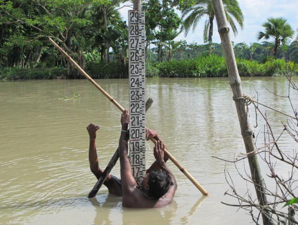
| Team member Manual George takes a water level reading (photo courtesy of Dr. Khan). |
The two most sensitive geophysical processes that exacerbate coastal vulnerability in Bangladesh are sea level rise and land motion (uplift/subsidence). However, our understanding of current and projected patterns of these factors remains incomplete. This incomplete knowledge is a key hurdle to converting our scientific understanding to actionable knowledge. Thus, improved understanding of sea level rise and land motion patterns is critical for improving long-term adaptation policy against coastal vulnerability in Bangladesh. In addition, understanding of the intra-seasonal dynamics of sea level in the estuarine regions is also critical for improved forecasting of the recession phase of an upstream flood wave that drains into the Bay of Bengal. Given the current gaps in science and application needs for the sustainable development of Bangladesh, this project will implement a satellite data-based integrative modeling framework that will operate in a porous manner with a recently funded NSF Belmont-G8 project awarded to U.S.-based University of Washington (UW). This NSF project is titled: Bangladesh Delta: Assessment of the causes of sea level rise hazards and integrated development of predictive modeling towards mitigation and adaptation (
BAND-AID). The project will build on a long-standing capacity building agenda for Bangladesh established by UW and the Institute of Water Modeling (IWM, http://
www.iwmbd.org) since 2006. Under the leadership of PI Zahirul Haque Khan of IWM’s Division of Coast, Ports and Estuary (CPE), the project will study sea-level rise and land motion in coastal Bangladesh at select sites by combining satellite geodetic data within-situ GPS/tidal measurements. The integration of satellite data (gravimetry, altimetry and interferometry) will be the first of its kind in Bangladesh for revealing accurate snap shots on current rates of sea level rise and land uplift/subsidence in the coastal regions. In addition, an improved monitoring of downstream boundary condition on water levels with water level sensors in the Meghna estuary will lead to enhancement of flood forecasting skill from 8-day to 12-14-day lead times. The key scientific question that motivates this project is: How cost-effectively and sustainably can IWM improve the understanding of coastal vulnerability and flood forecasting skill in Bangladesh using a satellite data integrative modeling framework without the need for external support?
The involvement of IWM-Bangladesh as the lead institute in this NSF-USAID PEER initiative is of utmost importance given the existential role of sea level rise on Bangladesh. The NSF-Belmont Forum 13-nation consortium, of which UW is a collaborating U.S. institute, does not include Bangladesh as a participating nation. This means that the participation of IWM in the NSF
BAND-AID project has up to now been in-kind only, despite the critical role of IWM in addressing an existential issue for Bangladesh. Award of a PEER grant to IWM will ensure the rapid realization of several developmental impacts for Bangladesh. These impacts pertain to food security, climate change, water security, and improved water management. The specific developmental impacts expected from this PEER project are as follows. First, through planned human resource training of key IWM-CPE staff by Belmont G-8 institutions on the state of the art satellite gravimetry, altimetry, interferometry and in-situ GPS sensor recording, IWM will become (from 2017) an independent user and trainer of this emerging satellite technology for cost-effective monitoring of sea level rise and land motion for the Government of Bangladesh. Second, through intra-seasonal (daily) monitoring of water level in Meghna river estuary, the currently successful 8-day satellite altimeter-based flood forecasting system built by UW in collaboration with IWM (see
http://apps.iwmbd.com/satfor) will improve to 12-14 days of warning by 2016. This will consequently improve pro-active flood disaster management for Bangladesh Government in 2017. It will allow more resilient agricultural planning at the micro-economic level through immediate dissemination of forecasts on affordable mobile platforms (cell-phones) that have already been built by UW (see
http://climate.cae.tntech.edu) to farmers for early harvesting or delayed sowing of crops. Third, completion of this project will make IWM a role model institution for adoption and training of emerging satellite technology for hazards assessment/mitigation in the region. This consequently will position IWM and Bangladesh as a regional trainer hub for other South Asian stakeholder agencies with a significant reduction in future training costs for USAID.
Final Summary of Project Activities
In the final year of this project, which was completed as of November 30, 2017, Dr. Khan and his colleagues worked to build on the results of the cyclone-induced storm surge hazard assessment and exposure analysis they had completed earlier in the project for nineteen severe cyclones. In particular, they completed a dedicated storm surge model for the 1991 cyclone that hit the Chittagong coast with a maximum wind speed of 225 kph during high tide. The simulation results highlighted the maximum surge height along the Chittagong coast and nearby islands and predicted the levels of increased surge heights that could be expected in 2050, given anticipated climate change effects. Sandwip Island could be especially hard hit by inundation. The team also applied an innovation in their mathematical model in order to assess the effectiveness of mangroves as a coastal barrier during cyclones. The model allowed them to test out the potential effects of planting mangroves in bands of various widths (50 to 1000m) along the shores of Sandwip Island and seeing how such plantings could affect the surge height at various points on the island. The results have shown differing impacts based on the width of the mangrove bands, bathymetry, and other geographic conditions. The team has concluded that reducing surge height even by a few centimeters in key spots could save thousands of lives, as well as property. Therefore, mangrove afforestation can play a vital role in coastal areas of Bangladesh as a barrier against cyclone-induced storm surge. Although the project has ended, the PI and his team will continue to work on publishing their results, upgrading their models, and further applying them in efforts to predict and mitigate future storm surges. The researchers are well positioned to make an impact, thanks to their close collaboration with crucial government agencies, including the Bangladesh Water Development Board, the Bangladesh Meteorological Department, and Water Resources Planning Organization, and the Survey of Bangladesh.
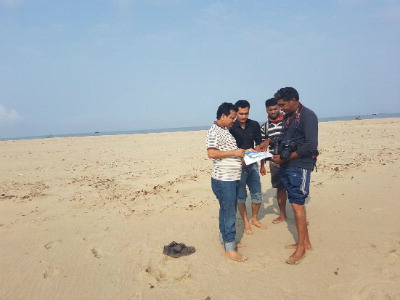 | 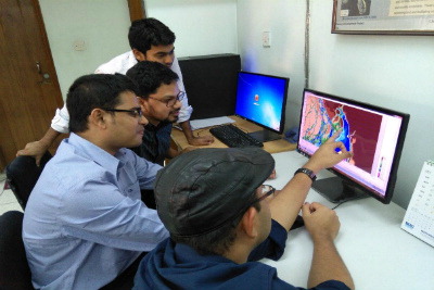 |
| IWM senior professionals visit Sandwip Island | IWM researchers discussing storm surge model development
(photos courtesy of Dr. Zahirul Khan) |


