|
Cycle 7 (2018 Deadline)
Integrated geoscience studies for hazard mitigation at the Agung-Batur Volcanic System, Bali, Indonesia
PI: Sri Widiyantoro (sriwid@geoph.itb.ac.id), Institut Teknologi Bandung (ITB)
U.S. Partner: Jacob Lowenstern, USGS Cascades Volcano Observatory
Dates: November 2018 - November 2021
Project Overview
After more than 50 years of slumber, Agung volcano erupted explosively on November 21, 2017. The eruption followed a seismic crisis that began more than two months prior when nearby earthquakes reached rates greater than 1,000 events per day. During the crisis, Indonesian and USGS/Volcano Disaster Assistance Program (VDAP) partner scientists feared a repeat of the previous eruption in 1963, when more than 1,500 people perished as high-speed pyroclastic flows swept down the mountain’s slopes into nearby settlements. Fortunately, the ongoing eruption of Agung seemed to wane by April 2018 without resulting in any deaths up to that point. Authorities succeeded in evacuating at-risk populations prior to the eruption, and these efforts plus the limited size of the eruption prevented a repeat of the 1963 disaster. Despite this success, the recent eruption of Agung has surprised volcano scientists in several ways. The eruption happened more than a month after the peak in seismicity when earthquake rates were relatively low. When it did occur, it happened without obvious seismic precursors. In addition, although the eruption occurred in the summit crater of Agung, later analysis of satellite data suggests that the intrusion of magma that triggered it actually occurred northwest of the volcano, in between Agung and neighboring Batur caldera. Batur erupts more frequently than Agung, most recently in 1999, and an eruption also occurred just a few months after the 1963 eruption at Agung. The location of the recent magma intrusion and the timing of the 1963 eruptions suggest a link between the two volcanoes. Although the current concern is focused on Agung, renewed unrest at Batur would be equally concerning given the density of the at-risk population in and around the caldera. Together, these two volcanoes present significant hazards to hundreds of thousands of residents and tourists in Bali, and relatively little is known about the magmatic system that will feed future eruptions. With their USGS collaborators, the PI and his team will carry out a suite of geophysical studies to better understand the Agung-Batur volcanic system and the hazards it presents. The main goals of this PEER project are: (i) to better understand the physical processes culminating in the recent eruption of Agung, (ii) to estimate future hazard potential, (iii) to provide additional analysis of the volcanic activity to policymakers, and (iv) to support a campaign of volcanic disaster risk education for the community.
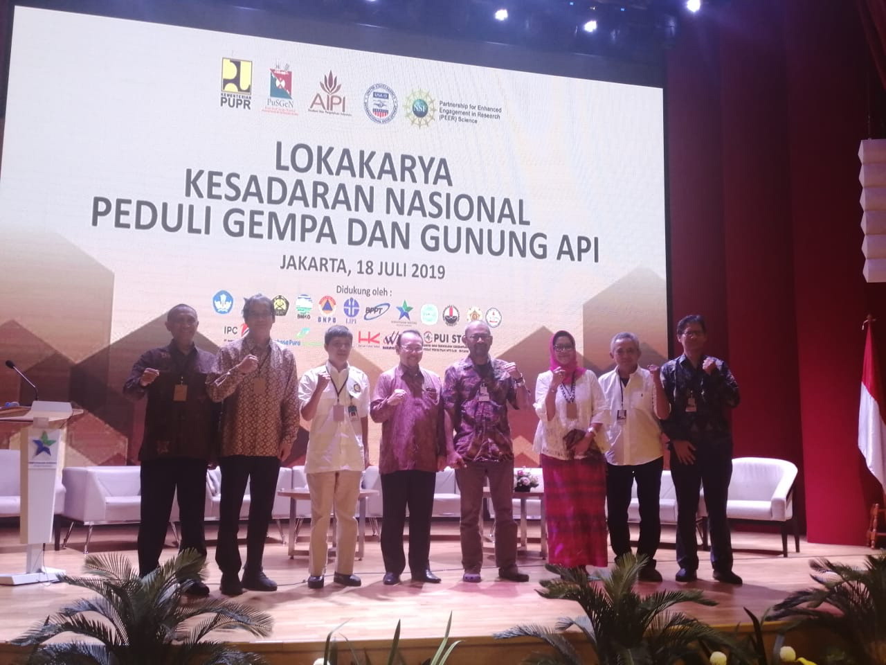 | 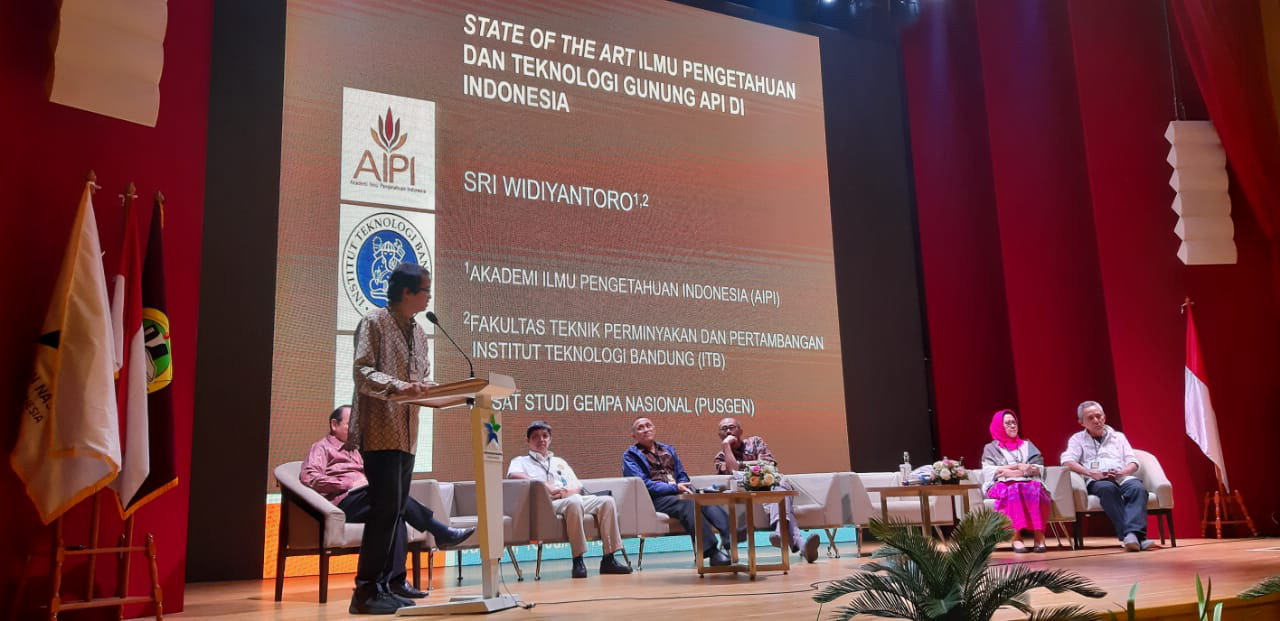 | | Together with the Ministry of Public Works and Housing, the Indonesian Academy of Sciences, and the National Center for Earthquake Studies, the PI Dr. Widiyantoro [shown speaking at right] and his team held a national workshop in Jakarta on July 18, 2019, on the topic “National awareness of the threat of earthquakes and volcanoes.” Photos courtesy of Dr. Widiyantoro. |
The long-term safety of people in their homes and their livelihoods depend on the ability of scientists to properly assess the current state of unrest at the volcano. The research carried out under this project will improve our understanding of volcanic processes and thus our ability to forecast future eruptions, both at Agung and Batur, and also at other similar volcanoes worldwide. In Bali, these forecasts directly impact the safety of hundreds of thousands of people located in the hazard zones, including many poor and vulnerable communities. Improving eruption forecasts and volcanic hazard education in Bali will help ensure the safety of at-risk populations and minimize economic losses in future eruptions. The geophysical studies to be conducted will also strengthen collaborations among Indonesian government agencies (the Center for Volcanology and Geological Hazard Mitigation and the Disaster Mitigation Research Center), university colleagues at ITB, and USGS/VDAP scientists. Although relationships among these partners currently exist, the Agung volcanic crisis has highlighted the advantages that greater collaboration between Indonesian government and university experts would bring to eruption forecasting efforts. The project will serve as a model for further collaborative efforts to improve volcano monitoring and risk mitigation in Indonesia, the country with the most historically active volcanoes in the world (Siebert et al., 2010).
Final Summary of Project Activities
This three-year project, which ended in November 2021, was aimed at understanding the physical processes underlying Agung volcano using newly acquired seismology, GPS geodetic, and geological data, as well as delivering the information to stakeholders through several outreach activities. Due to the outbreak of COVID-19, travel to Bali was difficult. Therefore, in the third year, the PI Dr. Widiyantoro and his team had to shift the focus of the research to the Bandung area. They applied the technique developed in Agung through this research to the Greater Bandung area to monitor the seismic activity of Lembang fault and Tangkuban Perahu Volcano monitoring.
Scientifically, the main challenge in understanding the physical processes that are the focus of this project is the limited available seismology, GPS, and geology data. Therefore, this research aimed to address the problem though collaboration among Indonesian government agencies (the Center for Volcanology and Geological Hazard Mitigation—CVGHM), university colleagues (Institut Teknologi Bandung—ITB), and U.S. Government-supported partners (the Volcano Disaster Assistance Program of the U.S. Geological Survey—USGS/VDAP). Although relationships among these partners already existed prior to this PEER project, the Agung volcanic crisis highlighted the advantages that greater collaboration between the Indonesian government and university experts would bring to eruption forecasting efforts.
The main results of this PEER project can be summarized as follows:
1. Newly acquired Integrated geosciences data on the Agung-Batur volcano complex: The installation of integrated geosciences stations to monitor the activity of the Agung volcano started in mid-December 2018. The installation was helped by CVGHM, which provided accommodations and legal assistance during the survey. In total, 25 new seismological stations and 4 geodetic GPS stations covering the Agung-Batur complex volcano were installed thanks to the PEER project. The data were used as the basis for the project team’s scientific analysis, the results of which they published in several journals and conference proceedings and socialized to the community through numerous outreach events.
2. Newly acquired Integrated geosciences data on the Lembang fault and Tangkuban Perahu volcano: The researchers deployed a total of 65 seismographic stations across Tangkuban Parahu volcano and the Lembang fault, West Java, Indonesia for seven months from November 2020 to June 2021. The 14 seismographs consist of six from the PEER Program, four from ITB, and four rented from an external party. The deployment was done five times by using 14 moving instruments for a one-month observation period for each term. The team further added 8 rented stations in the last 2 months to augment the station coverage for the Tangkuban volcano.
3. Conference presentations: The results of the PEER research have been disseminated in 11 conferences from 2019 to 2021. The published proceedings cover all geological, seismological, geodetic aspects of volcano monitoring. The novelty of this research comes from the integrated volcano monitoring performed, which could illuminate the ascent of the magma migration through various methods.
4. Journal publications and copyrights: Eight international journal publications during the research period (2019-2021) cover all geosciences aspects of volcano monitoring. Five of the publications had been published and three others were still under review as of the end of December 2021 in reputable international journals. The citation rate of some of the publications is already high, indicating that the results obtained in this study are having a great impact in the academic community. In addition to the publications, the research team also produced four software solutions that have been granted Indonesian copyrights.
5. Dissemination and outreach: The project team carried out nine dissemination and outreach programs during the study period. The spectrum of their outreach program was very wide, from technical disseminations to the Indonesian institution responsible for volcano monitoring (CVGHM) to hazard mitigation and anti-hoax training for people living near volcanos. The public outreach and training campaigns were conducted in collaboration with community organizations and local schools.
6. Educational Impacts: Taking into account the comprehensive geoscience understanding gained during the project regarding volcanic hazard mitigation in Indonesia, the PI and his team at ITA have updated existing course materials and added new courses related to earthquake and volcano mitigation. These updated and new courses are in the Geophysical Engineering Master’s program, the Geological Engineering Master’s program, and the Geodetic and Geomatics Engineering Master’s program.
Although the PEER project has ended, the PI and his colleagues plan to continue their work in collaboration with their U.S. partners and Indonesian stakeholders. They will apply the knowledge of volcano monitoring they gained during their research on Agung volcano to other volcanoes in Indonesia. Through their PEER project, they showed that integrated data management and processing could increase the accuracy of the volcano monitoring decisions. For instance, they showed that the seismic crisis that occurred prior to the 2017 Agung eruption indicated the reactivation of the nearby fault and not necessarily an imminent eruption. By the end of 2021, the team had already received an additional $57,000 in funding from Indonesian sources to continue their work, and with the data they have in hand and the technical infrastructure built under their PEER project, they feel confident in their ability to attract further sponsors.
Publications, Videos, and News Reports
Sahara, D.P.et al. 2021. Use of Local Seismic Network in Analysis of Volcano-Tectonic (VT) Events Preceding the 2017 Agung Volcano Eruption. Frontiers in Earth Science 9 (342). DOI: 10.3389/feart.2021.619801
Kusumawati et al., 2021, Fault Instability and Its Relation to Static Coulomb Failure Stress Change in the 2016 Mw 6.5 Pidie Jaya Earthquake, Aceh, Indonesia. Frontiers in Earth Science 9 (282). DOI: 10.3389/feart.2020.559434
Ardianto et al., 2021. Imaging the subsurface structure of Mount Agung in Bali (Indonesia) using volcano-tectonic (VT) earthquake tomography. Frontiers in Earth Science 9. DOI: 10.3389/feart.2021.619587
Zulfakriza, Z., Nugraha, A. D., Widiyantoro, S., Cummins, P. R., Sahara, D. P., Rosalia, S., et al. 2020. Tomographic imaging of the Agung-Batur Volcano Complex, Bali, Indonesia, from the ambient seismic noise field. Frontiers in Earth Science 8. https://doi.org/10.3389/feart.2020.00043
Albino, F., Biggs, J., & Syahbana, D. K. 2019. Dyke intrusion between neighbouring arc volcanoes responsible for 2017 pre-eruptive seismic swarm at Agung. Nature Communications 10(1), 748. https://doi.org/10.1038/s41467-019-08564-9.
Syahbana et al. 2019. The 2017–18 activity at Mount Agung in Bali (Indonesia): Intense unrest, monitoring, crisis response, evacuation, and eruption, Scientific Reports 9, 8848. https://doi.org/10.1038/s41598-019-45295-9.
“Seismicity and Tomographic Imaging of Agung Volcano,” June 5, 2020, presented by Dr. Devy K. Syahbana, Dr. David P. Sahara, and Dr. Zulfakriza (https://youtu.be/yiUG9PnOnZ0)
“Deformation of the Agung Volcano,” June 12, 2020, presented by Dr. Irwan Meilano, Dr. Endra Gunawan, and Dr. Asep Saepuloh (https://youtu.be/2knK9eq4vRU)
“Geovirtual of the Agung Volcano: from Surface to the Deep,” June 19, 2020, presented by Dr. I.G.B. Eddy Sucipta, Dr. Asep Saepuloh, and Adzkia Norma Arifa (https://youtu.be/PDqO5rf2Ba8)
https://balebengong.id/agar-sekolah-rawan-bencana-tetap-siaga/
https://www.itb.ac.id/news/read/56959/home/itb-lakukan-studi-terpadu-untuk-memahami-dinamika-gunung-agung
https://siedoo.com/berita-15427-pahami-dinamika-gunung-agung-itb-lakukan-studi-terpadu/
http://www.balipost.com/news/2019/01/16/66241/ITB-Pasang-Alat-Pendeteksi-Gempa...html
Copyrights
"DIGI" software for databasing digital geosciences data recorded during volcano monitoring. One problem in volcano monitoring is that there are several data monitoring formats from various studies. It is difficult to integrate the data, but this software facilitates standardizing the data format and data type and storing them in a database. This software has been granted copyright from the Indonesian government in 2020 No. 039/DivKI-ITB/SPMH/XI/2020.
"Geomecca: automatic Moment Magnitude Detection using Spectral Analysis" software for automatically determining the moment magnitude of a seismic event. This will help CVGHM in analyzing the status of ascending magma intrusion by using magnitude event data in semi-realtime. This software has been granted copyright from the Indonesian government in 2020 No. 000222427 on December 1, 2020.
"Geomecca: A Software For Magnitude Of Completeness and b-value Estimation" software for automatically determining the b-value or the specific number representing the magnitude distribution of seismic events. b-value is very helpful in analyzing the stress level on the rock and will help CVGHM analyze the status of ascending magma intrusion by using magnitude event data in semi-realtime. This software has been granted copyright from the Indonesian government in 2020 No. 000180183 on February 19, 2020.
"qtTomoDD" software for imaging the velocity structure beneath surface using recent technology of Double Difference. The software also incorporates a waveform cross-correlation technique for improving the resolution of the velocity structure. This software has been granted copyright from the Indonesian government in 2021 No. 000276530 on September 29, 2020.
Back to PEER Cycle 7 Grant Recipients
|
|
|
|


