|
Cycle 8 (2019 Deadline)
Impacts of alluvial mining in the Madre de Dios Basin: physical effects and mitigation planning
PI: Mónica Moreno Brush (mmorenob@utec.edu.pe), Universidad de Ingeniería y Tecnología
U.S. Partner: Eddy Langendoen, United States Department of Agriculture/ Agricultural Research Service
Project Dates: January 2020 - June 2022
Project Website: https://sites.google.com/utec.edu.pe/rivermining/ (includes links to research briefs under the Publications tab)
Project Overview:
Despite many efforts in the Madre de Dios Basin to estimate the impacts of alluvial gold mining with regard to mercury concentration, deforestation, and socioeconomic implications (e.g., human trafficking, tax evasion), very few investigations have been conducted to understand the effects of extensive alluvial mining operations on the rates of sediment supply and morphodynamics of the rivers in southeastern Peru and on the spatiotemporal distribution of mercury concentrations. This is a time-sensitive project because mining activities advancing rapidly, producing drastic physical alterations to river systems, and the Peruvian National Government lacks adequate impact assessment methodologies of alluvial mining concessions, many of them already operating. Currently, basic analyses with satellite imagery feature these assessments, rather than analyses with multi-temporal and historical data to elaborate predictive models to determine principal sources and sinks of mercury across the watershed and gold deposits that indicate potential areas to be targeted for mining. The location and topography of the Madre de Dios headwaters, where alluvial gold mining occurs, create a high potential for escalating this environmental and public health problem, putting large portions of the basin at risk. There is a critical need to provide both a baseline of river morphodynamics and linkages between aquatic ecosystems and landscapes to develop not only decision-relevant indicators for environmental quality but also methods for identifying trends to determine environmental quality in the future.
This PEER-supported project will involve an integrated assessment of a coupled natural-human system in southeastern Peru where there is an urgent need to develop science-based sustainable practices and conservation of natural resources. By combining state-of-the-art techniques in field measurement, remote sensing, and mathematical modeling of riverine processes, this project will explore the interactions between flow, sediment transport, and channel change in rivers in association with the distribution of mercury along the food chain. The outcomes will provide useful insights for land managers and decision makers on river morphodynamics and function, a crucial gap in the understanding of rivers, currently a critical national priority for Peru. Local authorities and partners working in the region will be encouraged to share their knowledge about sediments in rivers in the area, as well as gaps that can be fulfilled with this research. They will also be encouraged to incorporate best practices and environmental standards in their management efforts and to include river morphodynamics as a component of natural resource management. Developing a more sustainable approach for the use and monitoring of the environment will promote and support responsible economic activity in the Amazon region through viable economic alternatives to illegal exploitation of natural resources and the development of alternative processes for extracting gold with the least possible negative impact on the surrounding ecosystems.
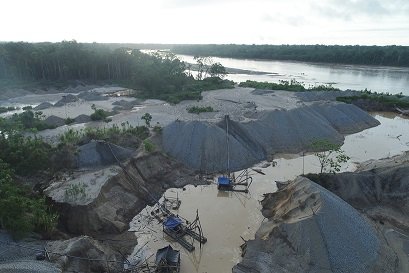 | 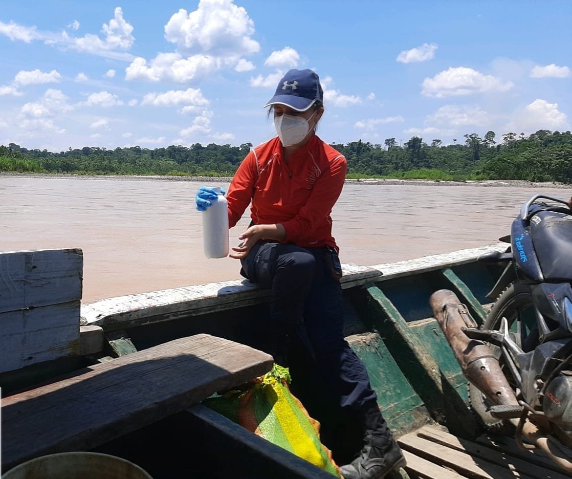 | | The mining site in the study area. | A member of the research team collects sediment samples on the river (photo courtesy of Martin Pillaca). |
Final Summary of Project Activities
Despite launching in January 2020, only two months before the start of the COVID-19 pandemic, this PEER team managed to overcome the many challenges they faced to accomplish their multi-faceted research and dissemination objectives. Following is a compilation of their activities and achievements on the various work packages involved:
1. River morphology
a. Hydrogeomorphology: The team’s analysis of the riverbed dynamic of the Madre de Dios River confirmed the impact of mining-derived riverbed aggradation (accumulation of gravel and boulders on the river bottom) on the natural physical dynamic of the river. The Madre de Dios River naturally transports sand and gravel, but riverbed aggradation due to mining activities increases the size of the riverbed material, reducing the capacity of the river to transport or move it. Continuous physical monitoring of the river water and sediments is necessary to have a comprehensive characterization of the river's dynamic and hydrogeomorphic processes and will help to design adequate mitigation actions against human activities such as mining and infrastructure projects.
b. Remote sensing: The effect of alluvial gold mining activities on the morphological change of the Madre de Dios River was investigated through the analysis of satellite images of a river section of about 330 km covering the period 1984-2020. The evaluation of six morphological parameters showed that mining activities conducted along the river have changed the river’s morphology (morphometry) and fluvial processes (morphodynamics). During the study period, the Madre de Dios River naturally experienced significant morphological changes in its fluvial dynamics, but these changes are concentrated upstream from mining activities. The identification of anthropogenic morphological changes in river sections where intense mining is or has been conducted suggests that mining intensifies or modifies the natural morphological changes of the river. This is the first study to report a quantitative analysis of the morphometric and morphodynamic changes in the Madre de Dios River.
2. Numerical Modeling
The researchers applied the hydrological model Soil and Water Assessment Tool (SWAT) to evaluate the hydrological response of the Madre de Dios River basin to land use and land cover changes. The analysis of three different scenarios of deforestation by gold mining demonstrated the susceptibility of the sub-basins of the Colorado and Puquiri rivers to changes in land use and land cover. The implementation of more hydroclimatological monitoring stations in the Madre de Dios River basin would enable a more efficient hydrological modeling for better decision-making in the management and management of alluvial mining impacts.
3. Hydrobiology
One objective of this study was to do a fast biological inventory of the Madre de Dios River and its three tributaries—Chilive, Colorado, and Inambari—as well as verify the state of conservation of the aquatic communities in relation to the presence of gold mining activities. Research findings suggest that periphyton could be an environmental quality indicator in rivers affected by gold mining. A gradual decrease in fish richness (in terms of number of species) was observed along the Madre de Dios River as it enters the mining area, suggesting a possible impact due to this activity. In the sampling locations with mining activities, the aquatic communities of ichthyofauna and macroinvertebrates had a different diversity distribution than in places without mining. Overall, the research findings suggest that macroinvertebrates, periphyton, and ichthyofauna are possible good indicators for evaluating the impact of alluvial mining in rivers and streams and could be used as a methodology for monitoring the impact of mining in the study area and other areas affected by alluvial gold mining.
4. Mercury Pollution
a. Mercury transport in rivers: An update on mercury distribution in sediments from the Madre de Dios River and its mining-affected tributaries Inambari and Colorado was made. Additionally, the team studied the influence of hydrodynamic and sediment transport on riverine mercury transport. In bottom sediments, mercury was found enriched in the fine fractions (clay and lime), confirming the need to consider grain-size distribution when investigating mercury in sediments. Furthermore, as in other Amazonian rivers, mercury in the study rivers was mainly found to be transported adsorbed to suspended sediments, and the mercury load in rivers strongly depends on river hydrodynamics and sediment transport, but also on the location of mining activities, which increase natural erosion by dredging. Among the two studied mining-affected tributaries, the Inambari River was found to contribute about 5 times more water, 7 times more suspended sediment, and 10 times more bottom sediment to the Madre de Dios River than the Colorado River. Thus, the Inambari River is the main contributor of sediment and mercury to the Madre de Dios River. This is the first study to investigate mercury transport and load in rivers affected by gold mining activities by combining mercury, hydrodynamic, and sediment load data.
b. Mercury in fish: A rapid risk assessment of the impact of gold mining activities on the ecotoxicological risk of the wildlife (fish and birds) of the Madre de Dios River showed that carnivore fish have the highest mercury levels, confirming that mercury biomagnifies along the local food web. The consumption of carnivore fish might represent a higher risk of exposure for human and wildlife populations given that most detected contractions surpassed the toxicological reference values reported in the literature. Higher mercury levels in carnivore fish from areas with mining compared to areas without mining suggest that mining activities increase mercury levels in fish. Therefore, the consumption of fish, especially carnivore fish, from mining-impacted areas may pose a health risk to Amazonian piscivore birds. The implementation of a standardized protocol for monitoring mercury in fish would serve to analyze concentrations and potential risks for consumers throughout time.
This PEER project was especially notable for its emphasis on outreach and dissemination of the research findings, and the team included dedicated communications specialists to ensure this aspect was well covered. The research findings and technical recommendations of the project were communicated and disseminated in a total of 18 webinar talks, 2 workshops, and 11 scientific conference contributions. Communications deliverables such as a technical report, media material (press notes, promotional videos, and social media posts), and a project website were also produced. Six research briefs to communicate the research findings of each work package have also been produced for publication. In her final report on the project, PI Dr. Monica Moreno Brush notes that the activities and communication products efficiently brought the scientific and technological knowledge produced by the project to policymakers. The technical webinars were a space to communicate the research findings of the project beyond academic circles and to promote them in policymaking. They were also a space to interact with researchers from Peru and abroad working on the topics of watershed management and gold mining in the Amazon region. The discussion panels in the webinars and workshops brought scientists and policymakers together to discuss common issues in the Madre de Dios region and were a space that enabled the project to persuade government agencies and decision-makers to adopt research-supported recommendations on how to effectively assess and monitor the morphological changes and mercury pollution in Amazonian rivers affected by gold mining activities.
The outreach activities on the project elicited very favorable feedback from the stakeholders who participated. The director of the Water Administrative Authority of Madre de and Dios highlighted the importance that his organization starts considering the hydraulic and physical data of the rivers when interpreting their results, and how important it is to use technology such as drones and riverbed profilers when monitoring rivers. In the same way, the Sub-Manager of Territorial Conditioning of the Madre de Dios Regional Government acknowledged the relevancy of the information provided during the workshop and that it could be an important contribution to the regional development plan. The Service of Protected Areas for the State (SERNANP) expressed its interest in including the methodology and recommendations of the project for assessing and monitoring streams and rivers in the next Management Plan of the Tambopata National Reserve. The conversations are to resume after the project publishes its research results. Meanwhile, the data and results generated by the Remote Sensing work group have been published in the open access data portal Dancing Rivers developed by CITA-UTEC.
Although the PEER project has ended, the Water Research and Technology Center (CITA) from the University of Technology and Engineering (UTEC) will remain active in the search for additional funding to continue working on the environmental impacts of small-scale artisanal mining and finding solutions for their mitigation. Their plan includes writing proposals for funding in Peru and abroad in collaboration with their local and international partners. They also plan on publishing research papers that include their more relevant and original findings.
Back to PEER Cycle 8 Grant Recipients
|
|
|
|


