Contact Us  |  Search  
 
The National Academies of Sciences, Engineering and Medicine
Partnerships for Enhanced Engagement in Research
Development, Security, and Cooperation
Policy and Global Affairs
Home About Us For Grant Recipients Funded Projects Email Updates
PARTNERSHIPS FOR ENHANCED ENGAGEMENT IN RESEARCH (PEER)
Cycle 9 (2020 Deadline)


Climate mitigation potential of Colombia’s lowland peatlands: distribution, emission factors and conservation priorities

PI: Juan Benavides (jubenavides@javeriana.edu.co), Pontificia Universidad Javeriana
U.S. Partner: Erik Lilleskov, U.S. Forest Service
Project Dates: April 2021 - April 2024

Project Overview:
 
9-116_Benavides fieldtrip
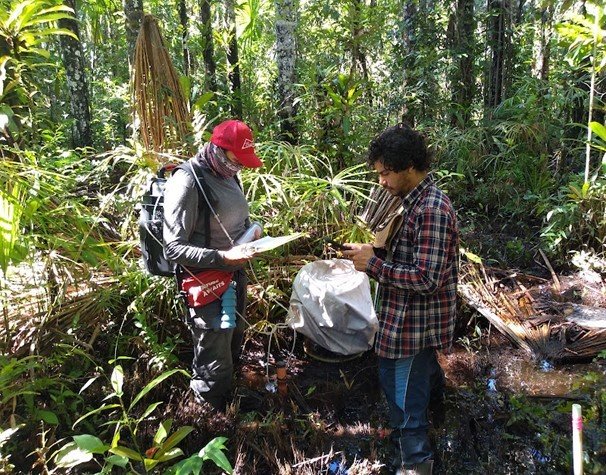
 Researchers Paola Alarcon (left) and Alejandro Delgado measuring CO2 and CH4 soil fluxes in flooded forests with peat soils in the Colombian Amazon. Photo courtesy Dr. Benavides
9-116_Benavides tropical peatland interior
Interior of tropical peatland where chambers for monitoring will be temporarily installed.
9-116_Benavides_meeting with local community
The meeting held in Chorrera on  December 13, convened 22 indigenous community representatives, including community guardian, women leaders, and grandparents of each community
9-116_Benavides_Paola at a workshop
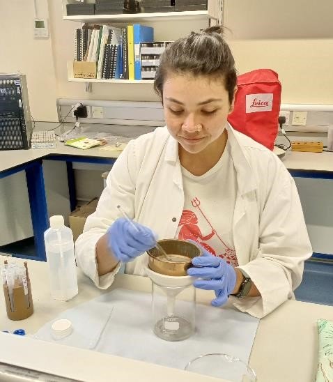
Paola Alarcon in the soil sample preparation workshop for C14 dating of peat samples from the Amazonian peatlands at the University of Exeter
Peatlands are the most carbon dense terrestrial ecosystems, harboring several times the carbon of non-peatland tropical rainforests per unit area. In addition, they are a major sink for greenhouse gases over millennial timescales, with global peatlands storing the equivalent of pre-industrial stocks of atmospheric carbon dioxide in just 3% of the land surface. However, these carbon stocks are vulnerable to land use changes (especially drainage) and consequent decomposition and burning, as well as to the warming and drying impacts of climate change. Therefore, understanding the distribution of, and threats to, peatlands is a critical part of our fundamental understanding of the earth system, as well as our ability to manage ecosystems to minimize impacts to climate, and to enable participation in international agreements that manage greenhouse gases.

Colombia has extensive lowland areas that are known to harbor peatlands, yet very little research has been done to characterize their extent and threats from land use/land cover change, disturbance, and climate change. Existing global mapping efforts of tropical peatlands by Gumbricht estimated about ~75,000 km2 of peatlands for Colombia, second only to Brazil in South America, and an area equivalent to that of Peru, a country that has been extensively heralded as a major peat-harboring country in South America. Yet this estimate has not yet been validated by ground truthing, begging the question of the validity of these estimates. Additionally, it is known that deforestation is substantial in this region (Armenteras et al. 2013) and that both forest fragmentation and fire can have major impacts in the lowlands of Colombia. However, because of the lack of information on peatlands, the intersections of these land use change and disturbances with peatlands is virtually unknown.

The goal of this project is to fill this gap, using a combination of mapping approaches based on remote sensing and ground truthing. In addition, the team will estimate the carbon stocks in these peatlands and provide the first information on the relative importance of soil efflux of methane and carbon dioxide from sites under different land uses. This information will enhance capacity to manage these ecosystems effectively and support national policy on greenhouse gas fluxes, as well as serve as a basis for building a more intensive study network using state-of-the-art ecosystem-scale greenhouse gas flux methods such as eddy covariance. The direct effects of the project will provide information on more precise accounting of carbon losses associated with deforestation and forest degradation in the Colombian Amazon by including the losses associated with large organic deposits of peat. Most of the national GHG emissions from Colombia are associated with deforestation in tropical lowland forests (IDEAM et al. 2017, Houghton and Nassikas 2018, Krause 2020). The reduction of projected emissions of GHG associated to deforestation is the main instrument for achieving the National Determined Contributions (NDC) agreed after the COP21 (IDEAM et al. 2017, Pistorius et al. 2017). The inclusion of peatlands as a separated land cover that is integrated with the national deforestation monitoring program will provide a more complete evaluation of the potential GHG emissions and will emphasize the role tropical peatplands play in climate change mitigation (Murdiyarso et al. 2019).

Project updates

The work carried out during April-June of 2023 in lowland peatlands has focused on three main components that are part of the project objectives. The first component concerns activities dedicated to mapping lowland peatlands throughout the Amazon region. The second component focuses on the activities and establishment of GHG monitoring zones in the Colombian Amazon region, and the third component includes all the approaches with local, indigenous, governmental, and business organizations, with which alliances have been made for the establishment of the project, in addition to the academic relationships that have been built from the project.
 
Mapping lowland peatlands throughout the Amazon region has been ongoing. In their laboratory, the team processed over 30 cores with  the loss ignition methodology to determine Carbon percentage and content and bulk density from the samples taken from Amazonas, Vaupes, and Caquetá. As part of the mapping activities, the team conducted visits to areas such as the Rey Zamuro Reserve located in San Martín, Meta, where extensive palm swamps were found associated with small water tributaries. Other visits were carried out within the Casanare department on the premises of a civil reserve called La Aurora. Cores were taken at each of these sites and are currently being processed. Additionally, the team held several meetings with the National Parks Authority to obtain permits to access various sites of interest for mapping lowland peatlands in the Colombian Amazon region.
 
For CO2 and CH4 monitoring, field trips were conducted to intensive monitoring sites in Inirida, Leticia, and Puerto Lleras. Measurements of CO2 and CH4 were taken at each monitoring site. In Inirida, the measurements focused on the flooded savannah,  Unfortunately, the flooded forest could not be monitored due to excessive water levels, making it inaccessible. In Leticia, monitoring was limited to the Cananguchal palm swamp. Measurements were also taken from trees and palms in the Morichal located in Puerto Lleras, Meta.A total of 20 vegetation individuals with a DBH greater than 10 cm were monitored, including 10 individuals from the Moraceae tree family and 10 individuals from the Mauritia flexuosa palm species. According to Dr. Benavides, CH4 measurement data for trees are crucial for understanding emission factors in the monitored sites, as methane is transported to the atmosphere through the vegetation structures, playing a significant role in estimating GHG respiration in these peatlands.
 
In terms of collaboration, meetings were held with the TroPeaCC group led by Dr. Angela Gallego-Sala to establish an intensive monitoring site in a flooded forest in Inirida. Partnerships have been formed with companies like Quanterra and the University of Exeter to obtain carbon dioxide and methane measurement sensors for establishing the eddy covariance tower. A one-month laboratory training was also conducted at the University of Exeter in England to learn about the methodologies used in paleoecology. Various activities were carried out related to sample processing, pollen analysis from tropical peat cores, sample processing for dating using lead-210 or radiocarbon, and data analysis for modeling to establish the age of the samples. Workshops were conducted on methane emission modeling in tropical peatlands and data analysis. Meetings were also held with Dr. Adriana Sanchez from the University of Rosario in Bogota to establish collaborations in understanding how CH4 fluxes from tree trunks and palms can be related to functional traits of trunk, root, and leaf of dominant species in palm swamps.
 
Accomplishments and challenges

During the development of the project the team accomplished most of their objectives and developed a strong database of recent and old carbon accumulation rates across peatlands under different disturbance regimes and vegetation types across the Colombian Amazon. They developed a strong relationship with the National Institute for the Environment of Colombia (IDEAM) aimed to the development of an updated version of the national GHG inventories and NDC. The team also developed a strong relationship with the local indigenous or farmers communities and actively engaged in providing information about the relevance of nature when counteracting climate change. They also participated in high level discussions about the ethics of carbon credits in the Amazon and the relevance of wetlands in this process. 
 
What remains to be accomplished is development of a reliable map. The team were missing ground truthing points from particular areas that are difficult to reach and have unique combinations of tectonic settings, climate and river activity that were visible on the preliminary maps that we produced. The team spent the allocated resources from the project visiting easy to reach sites and negotiating with local communities across the Amazon to have access to the sites and have them as coinvestigators in their project, but that strategy consumed the allotted resources given the rising costs of fuel and transportation to the sites. The project team visited over 60 location across the Colombian Amazon and collected more than 250 samples. 
 
Information is still missing from four specific sites that will greatly improve the quality of the map: (1) Mitu region: mix of poor sandy soils and black water rivers, (2) Caqueta region: tectonic depression across the Yari river, and (3) Putumayo region: wet forest on rich soils and Andean slopes. In September 2023, Dr. Benavide's PEER project received a supplement and additional time until April 2024 to complete these crucial PEER project related mapping activities.

 
9-116_Benavides_treacherous route to collect data 9-116_Benavides_Juan extracts peat from the swamp 9-116_Benavides_peat
Treacherous paths leading to the data collection site in the Amazonia, south of Colombia.  Juan Benavides demonstrates peat extraction from the swamp in the Amazonia during USAID and NAS field site visitsPeat extracted from the depth of the swamp in Amazonia


Back to PEER Cycle 9 Grant Recipients