Cycle 5 (2015 Deadline)
Using multi data for biodiversity conservation at Dak Nong Province in the Central Highlands of Vietnam
PI: Nguyen Thi Thanh Huong (huongthanh.frem@gmail.com), Tay Nguyen University
U.S. Partner: Volker Radeloff, University of Wisconsin–Madison
Project Dates: December 2016 - June 2021
Project Overview
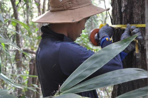 | | The team conducts data collection in the study area (photo courtesy of Dr. Nguyen) |
Development of sustainable forest management and conservation strategies requires an understanding of how the composition and structure of tropical forests change in response to different disturbance regimes and how this affects both species distributions and people living in and near these forests. Most forests in Vietnam are affected by land cover change (LCC) resulting from human activities. To map and quantify the patterns of LCC, Dr. Nguyen and her team analyzed Landsat satellite images, GIS data, and field inventory data to classify forests by type and disturbance status. They used these maps to stratify their field sampling and assess plant biodiversity among forest types and their changes following different levels of human disturbances (i.e., minor, moderate, and heavy impact). Furthermore, they compared tree composition and structure along different ecological gradients, such as topography. By combining remote sensing, field data, and statistical processing, they worked to advance current methods to measure disturbance and biodiversity in the Central Highlands, which are largely based on field inventories. However, remotely sensed data is likely insufficient to map rare and endangered species, and hence areas of high conservation value. Therefore, the researchers integrated spatial data with the experience of forestry workers and the indigenous knowledge of local people in the second phase of the project. Dr. Huong and her colleagues collaborated closely with their U.S. partner Dr. Volker Radeloff, who provided expert advice on forest sampling, analysis of vegetation diversity, and the use of remote sensing in ecology and biodiversity.
Final Summary of Project Activities
This project achieved its goals with regard to research and capacity building for both team members and staff from stakeholder agencies, production of scientific publications, and strengthening of collaborative linkages with Vietnamese and international research partners.
Outreach and collaborations were very important aspects of the project, and the PI and her team collaborated closely with both professional foresters and local residents, who were involved in many project activities, including discussions of problems related to forest management, participation in forest inventories, and training on relevant technical skills. Through these activities, foresters and citizens alike gained a greater understanding of the importance and status of rare and endangered tree species in their local areas, as well as approaches for more effective forest management. Through working with the PEER team, they learned how to use inventory tools, design field activities, and collect biophysical data. A total of 285 people participated in the project, including undergraduate and graduate students, lecturers from Nong Lam University and Tay Nguyen University, and forestry staff and residents from four provinces in Vietnam’s Central Highlands. Prior to the project, forestry staff at various levels in Dak Nong Province lacked any training in using remote sensing and GIS techniques in forest management. The PI reports that the training met their expectations and gave them confidence to collect and analyze forest data independently, skills that will be very useful in their fulfilling their forest management responsibilities. Three Master’s students and one undergraduate completed their degree requirements based on their work on the PEER project, with two subsequently being hired by provincial forest management agencies and two continuing as members of the PI’s research team. Three other PhD students on the project are completing their compulsory courses and beginning their research projects under the PI’s supervision.
At the time the final report on this project was received in August 2021, the PI and her colleagues had published 11 journal articles and conference papers, including one in the international journal Remote Sensing. At least two more papers and a book of technical guidelines are still in preparation. In addition, the PI and her colleagues presented their results at four workshops, culminating in a final one in April 2021 at which they transferred their final report to the Department of Agriculture and Rural Development (DARD), Department of Science and Technology, and Department of Planning and Investment for Dak Nong Province. The head of DARD emphasized they will use the results in updating and integrating the province’s development programs and plans.
In 2020-2021 alone, the PI and her team received five new grants or contracts for a total of about $125,000 to support their ongoing efforts on crop mapping, provision of remote sensing and GIS training, forest restoration, and organic agriculture development. The team was invited to serve as a core member of a national project conducted by the Vietnam Academy of Science and Technology (2018-2021). They are also contributing to other projects under Dak Nong Province agencies, and they have been invited to complete work packages related to community forest management, REDD+ (Reducing Emissions from Deforestation and Forest Degradation), and the forest value chain as part of a new project the International Fund for Agricultural Development—Green Climate Fund for 2022-2026. Dr. Huong notes that participation in the PEER program not only helped her team members develop their professional skills but also built a strong reputation for the group in the agro-forestry development sector. These aspects, combined with the enhanced research infrastructure from equipment and software bought with PEER funds, put the team in a strong position to compete for additional funding. In addition to the larger grants and contracts supported by Dak Nong Province agencies, Tay Nguyen University is also supporting small research grants for several team members.
Based on the experience and results obtained from their PEER project, Dr. Huong and her colleagues have established an official research team entitled Resources Integration Management, one of only four such research units at their university. In addition to following up on publishing additional papers resulting from their PEER-supported work and carrying out their newly funded projects, the researchers will be pursuing new opportunities to continue providing training, data, and recommendations to environmental agencies in their region and beyond.
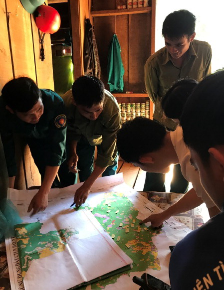 | 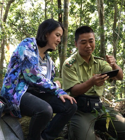 | | The research team discusses rare tree species with forestry staff. | The team training the head of the forest station on how to use GIS for monitoring forests with his mobile phone. |
Photos courtesy of Dr. Huong
Selected PublicationsH.T.T. Nguyen, T.N.Q. Chau, T.A. Pham, P.T.X. Tran, T.H. Phan, and T.M.T. Pham. 2021. Mapping land use/land cover using a combination of Radar Sentinel-1A and Sentinel-2A optical images. IOP Conf. Ser.: Earth Environ. Sci. 652 012021, doi:10.1088/1755-1315/652/1/012021 Nguyen Thi Thanh Huong, Trung Minh Doan, Erkki Tomppo, and Ronald E. McRoberts. 2020Land Use/Land Cover Mapping Using Multitemporal Sentinel-2 Imagery and Four Classification Methods—A Case Study from Dak Nong, Vietnam. Remote Sens. 2020, 12, 1367; doi:10.3390/rs12091367
H.T.T. Nguyen, T.A. Pham, M.T. Doan, and P.T.X. Tran. 2019. Land Use/Land Cover Change Prediction Using Multi-Temporal Satellite Imagery and Multi-Layer Perceptron Markov Model. The International Archives of the Photogrammetry, Remote Sensing and Spatial Information Sciences, Volume XLIV-3/W1-2020, 2020 Gi4DM 2020 – 13th GeoInformation for Disaster Management Conference, 30 November–4 December 2020, Sydney, Australia. https://doi.org/10.5194/isprs-archives-XLIV-3-W1-2020-99-2020
H.T.T. Nguyen, T.N.Q. Chau, T.A. Pham, T.H. Phan, P.T.X. Tran, H.T. Cao, Q.T. Le, and T.H.D. Nguyen. 2019. Land Use/Land Cover Changes Using Multi-Temporal Satellite. The International Archives of the Photogrammetry, Remote Sensing and Spatial Information Sciences, Volume VI-3-W1-2020, 2020 Gi4DM 2020 – 13th GeoInformation for Disaster Management Conference, 30 November–4 December 2020, Sydney, Australia. https://doi.org/10.5194/isprs-annals-VI-3-W1-2020-83-2020
Nguyen Thi Thanh Huong and Ngo Thi Thuy Phuong. 2018.Land use/land cover change prediction in Dak Nong Province based on remote sensing and Markov Chain Model and Cellular Automata. J. Viet. Env. 2018, 9(3):132-140. http://dx.doi.org/10.13141/JVE
Ngo Thi Thuy Phuong, Nguyen Thi Thanh Huong, and Vo Quang Minh. 2018. Detecting segmentation parameters to classify using Landsat 8 satellite image. Science Journal of Can Tho University 54(4A): 22-30. doi: 10.22144/ctu.jvn.2018.065 [in Vietnamese with English abstract] Back to PEER Cycle 5 Grant Recipients
|


