|
Phase 5 (2012 Deadline)
Neotectonic and Earthquake-hazard Studies of the Chaman Fault, Western Pakistan Shuhab D. Khan, University of Houston Khan Abudul Salam, University of Balochistan The Chaman strike-slip fault system is located close to megacities in Pakistan that host a major portion of the world’s population. Collision-related seismicity across this region has caused hundreds of thousands of deaths and catastrophic economic losses in this area. Neotectonic studies on the active Chaman fault will help earthquake prediction and mitigation. This project is to use radar and multispectral data and digital evaluation models to identify tectonically active regions; and to use Inerferometric Synthetic Aperture Radar (InSAR) and Global Positional System (GPS) to measure the slip rate of the Chaman Fault. It will train Pakistani scientists in the latest techniques for tectonic geomorphology, InSAR, GPS, and age dating, and build the capacity of the University of Balochistan.
Progress Reports
2014: The project is assessing temporal and spatial variations in displacement along the Chaman fault system. Specifically, tectonic landforms, geochronological and geodetic investigations are undertaken. With an overarching goal to help determine the role of this large intercontinental strike-slip fault in Afghan-Indian-Asian continental-continental convergence. In the first year of this project following was accomplished:
Tectonic Geomorphology
Remote sensing data were used to identify tectonically active zones by landform/landscape expressions on the surface, i.e., beheaded streams, stream offsets, deposition style of alluvial fans, drainage style, water gaps, and wind gaps. Figure 1 shows some of the prominent landforms in the Nushki basin. Five different generations of alluvial fans were mapped based on the distinct spectral and textural characteristics using satellite images from Google Earth. Three landform (geomorphic) indices for areas show actively uplifting area around the Chaman fault.
Geochronological Work
A total of 32 rock samples from surfaces on dominant landforms were processed for 10Be terrestrial cosmogenic nuclide surface exposure dating provide ages that ranged from ~700 to 26,000 years. 10Be ages on individual surfaces should be similar in age. There is quite some scatter of the ages, which is to be expected given the dynamic nature of Earth surface processes that modify landforms. However, the ages indicate that two dominant surfaces prevalent throughout the region date to ~5,000-7,000 years before present and ~2,000-3,000 years before present. Additional rock samples will be collected early next month for 10Be dating to help tighten up the age clusters to provide more robust ages for these surfaces.
Geodetic Investigations
Several sites across the Chaman fault system are selected for GPS surveys, at these sites GPS campaign data will be collected 2-3 times during the duration of this project. In the first year Pakistani colleagues collected GPS data at two locations more surveys are in progress. We have also acquired around 60 PLASAR, ERS 1, 2 and ENVISAT images for interferometric synthetic aperture radar (InSAR) analyses along Chaman fault and other major faults located east of Chaman fault.
Earthquake Rupture Study
On September 2013, a 7.7 magnitude earthquake was recorded along a fault associated with the Chaman fault system in southern Pakistan. Numerous satellite platforms, including Worldview 1 and 2, Geoeye, and Landsat 8, recorded data after the earthquake. In collaboration with United States Geological Survey (USGS) and California Institute of Technology, we are using data from around the epicenter of the fault to identify ground rupture, geomorphic changes and displacement along the fault trend. Collaborators from University of Balochistan are the only group who visited two sites along the ground break and collected field measurements and took valuable photographs.
Remote sensing data coupled with field photographs are helping to understand this spectacular and fatal earthquake.
Dr. Abdul S. Khan (PI) from Pakistani side visited University of Houston as a Fulbright fellow; he attended a week-long workshop on Optically Stimulated Luminescence (OSL) age dating techniques at the University of Cincinnati, from February 3 through 7. This has prepared him to undertake sample collection for OSL dating along the Chaman fault.
Project collaborators from University of Balochsitan; Dr. Abdul Khan, Mr. Din Kakar and Dr. Aimal Kasi were trained in the field in United States from March 12 till April 12, 2014. Dr. Lewis Owen and his group from University of Cincinnati organized a fieldwork for our Pakistani colleagues to examine well studied sites along San Andreas fault transform fault system in California and in the Basin and Range Province in Nevada. This included visits to Death Valley, Owen Valley, Long Valley, Smith Valley and Mason Valley and Lake Tahoe. Two US geology undergraduate students and a US lab manager from the University of Cincinnati participated in the field training. In addition, we also took a high school student from Mason High School (Ohio) with us in the field (Figure 8). This provided valuable interactions between US and Pakistan academics and students at a mixed range of stages in their careers. The group was joined by Dr. Steven Wesnousky (University of Nevada) and Shuhab Khan during the latter part of the field training, and focused on examining active faulting in the Smith Valley in Basin and Range Province. Visitors were trained on field measurement and sample collection for 10Be terrestrial cosmogenic nuclide and OSL dating (Figures 9 and 10). Pakistani colleagues were also trained GPS campaign data collection and processing in University. Several sites across the Chaman fault system were selected for GPS surveys. In the first year Pakistani colleagues collected GPS data at two locations. The team has also acquired around 60 PLASAR, ERS 1, 2 and ENVISAT images for InSAR analyses along the Chaman fault and other major faults further east. Remote sensing data was used to identify tectonically active zones according to landform characteristics three of which reveal an actively uplifting area around the Chaman fault. As part of an effort to identify relative rock ages around the Chaman Fault, a total of 32 rock samples from dominant landforms were processed. Ages were found to range from ~700 to 26,000 years. The ages indicate that two dominant surfaces prevalent throughout the region date to ~5,000-7,000 years before present and ~2,000-3,000 years before present. Additional rock samples will be collected soon. The Pakistani PI Dr. Abdul S. Khan met with Dr. Shuhab Khan at the University of Houston as a Fulbright fellow. While in the U.S. he attended a week-long workshop on Optically Stimulated Luminescence (OSL) age dating techniques at the University of Cincinnati. This has prepared him to undertake sample collection for OSL dating along the Chaman fault. Dr. Lewis Owen and his group from the University of Cincinnati organized additional fieldwork training in which Dr. Abdul Khan, Dr. Aimal Kasi, and Mr. Din Kakar from the University of Balochistan took part. Two US geology undergraduate students, a US lab manager from the University of Cincinnati, and a high school student from Mason High School (Ohio) also participated in the field training. They examined sites along the San Andreas transform fault system in California and in the Basin and Range Province in Nevada. Visitors were trained on field measurement and sample collection for Beryllium-10 terrestrial cosmogenic nuclide and OSL dating. Pakistani colleagues were also trained in GPS campaign data collection and processing. Meanwhile the University of Balochistan is in the process of purchasing two additional GPS units. While the planning stages of this project were being carried out, a 7.7 magnitude earthquake was recorded along a fault associated with the Chaman fault system in southern Pakistan. The team collaborated with the United States Geological Survey and the California Institute of Technology to identify ground rupture, geomorphic changes and displacement along the fault trend using data from around the epicenter of the fault. Team members from the University of Balochistan visited two sites along the ground break and collected field measurements and took valuable photographs. A number of publications and conferences were carried out during the year. Both Pakistani and U.S. PIs, along with Mr. Kakar presented their research on the 2013 earthquake in southern Pakistan at the 2013 Fall Meeting of the American Geophysical Union. Dr. Shuhab Khan and colleagues submitted an article for review in the journal Tectonophysics. He also joined Dr. Kasi and two others in writing an article on Pakistani mud volcanoes in the Arabian Journal of Geosciences. In addition, Mr. Kakar gave a presentation with colleagues on the 1945 Makran Earthquake at the 2014 Annual Meeting of the Geological Society of America in October. He plans to present supplemental information on the same topic at a 2015 conference in Oman. 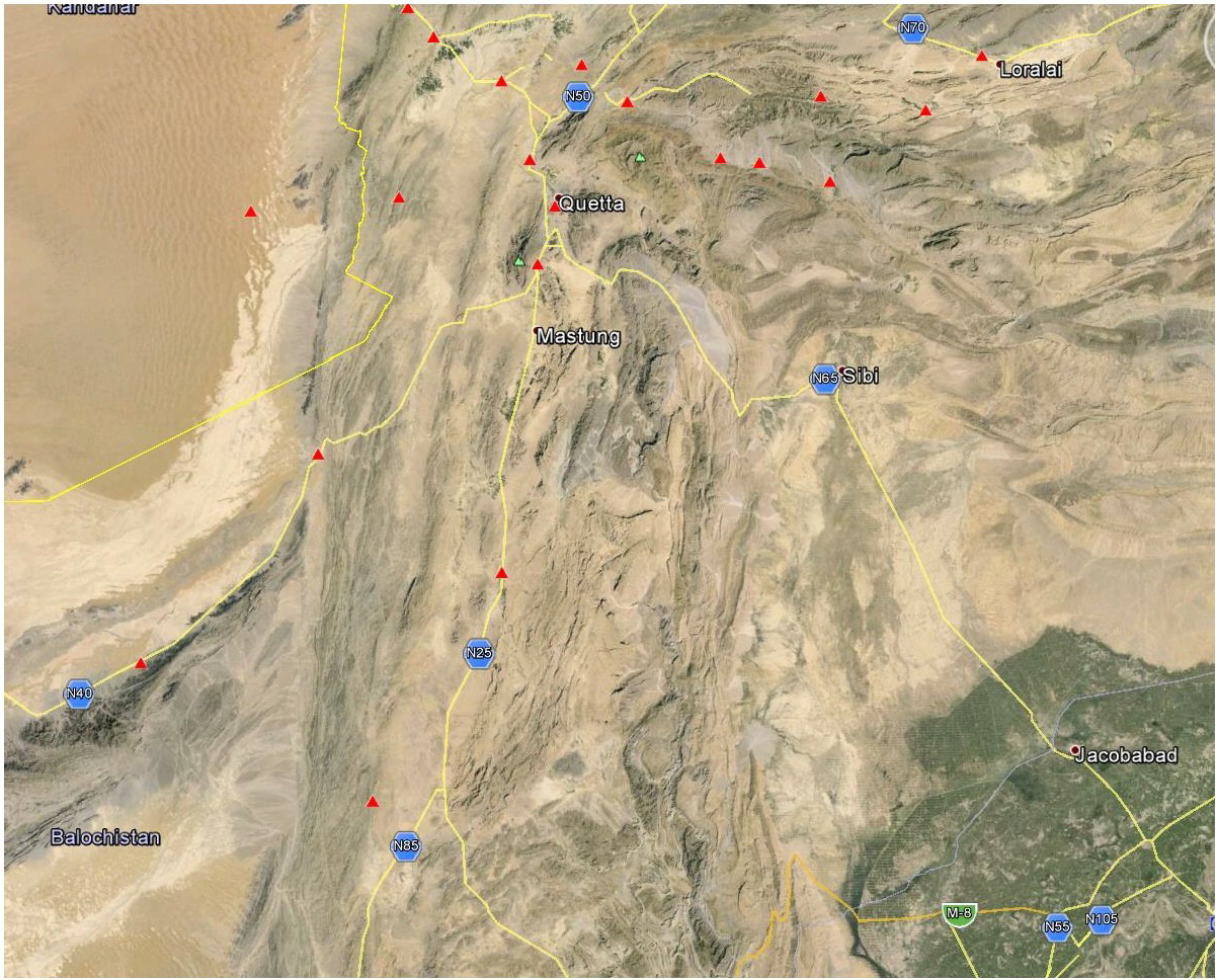 | Sites for GPS surveys shown by red triangles | 2015: Workshop
A two-day workshop “new geospatial tools for earthquake-hazard studies” was organized on December 21-22 in Quetta, Balochistan, Pakistan. Workshop included series of talks on earthquakes and related hazards in the region. The workshop was attended by more than 50 participants that included scientists, educators, students, and administrators (Figure 1). Dr. Khan taught several hands on exercises that utilized modern datasets and techniques for earthquake prediction and mitigations. Dr. Owen via Skype provided an overview on chronological techniques for the origin and tectonic evolution of topographic features, such as depressions and ridges.
Remote Sensing Work
Satellite remote sensing data were used for detailed geological mapping and to identify areas of active fault movement in the region. Published geologic maps were also digitized and used in conjunction with satellite data. A remote sensing technique, where satellite images taken at different times are combined, were also used for measuring ground movement along fault zones, which includes subsidence and uplift of ground. These results are supported by GPS surveys in the region.
Field Work
Two field trips were conducted by investigators from the University of Balochistan in the second year of this project. During these trips around fifty rock samples were collected along the Chaman fault for detailed laboratory analyses (Figure 2). All these samples are currently being processed in University of Cincinnati or at Prime Laboratory at Purdue University. In these field campaigns, several geological sections were measured and results of remote sensing data were confirmed.
Laboratory Analyses
Fifty rock samples were processed for age dating at Cosmogenic Laboratories, University of Cincinnati. In the initial proposal, we had planned to undertake the age dating of any collected rock samples using the Be-10 technique. This method requires that the collected rock samples contain specific mineral called quartz. However, many of the samples that were collected did not contain any quartz. In actuality, a large number of them were limestone, which contains only the mineral calcite. Fortunately, Professor Owen had just set up a laboratory at the University of Cincinnati to undertake Cl-36 age dating technique, which can be used in lieu of Be-10 on rocks and sediments devoid of quartz. Currently, all collected samples, which includes both the quartz-rich and quartz-devoid rocks, are being processed for Be-10 and Cl-36 techniques, respectively.
The samples are currently at the Accelerator Mass Spectrometry facility at PRIME Laboratory at Purdue University waiting to be measured.
2016: Tuberculosis is a curable disease provided appropriate drug therapy is administrated in a timely and appropriate manner. Pakistan is ranked 6th in the TB prevalence among 22 high burden countries. Over the last decade there has been substantial increase in drug resistance. Methods for accurate and cost effective diagnosis of infection with pathogenic Mycobacterium tuberculosis (M.tb). It is critical to detect M.tb infection in TB suspects as early as possible for effective treatment. Current methods have various limitations in terms of sensitivity, accuracy and cost effectiveness.
This project was aimed to build healthcare capacity in Pakistan by developing new blood based multiplex microbead diagnostic method for detecting active TB. This project on novel methods for TB diagnostics was designed to increase the capacity of science and technology to improve the wellbeing of the citizens of Pakistan and other TB endemic countries. Improved methods for detecting M.tb infection will enable physicians to initiate appropriate anti-TB therapy (DOTS) sooner. Results of our studies demonstrate that the prototype test developed in this project is more sensitive than the commonly used, WHO recommended procedure on microscopic determination of patient sputum. Such rapid and accurate TB testing methods will be important for healthcare workers as well as patients in clinics and hospitals. In addition, the collaborative activities and transfer of multiplex microbead immunoassay technology will improve the quality and capacity of infectious disease research at Pakistani institutions of higher education. This project may lead to establishing an intermediate level laboratory network consisting of one reference laboratory possibly in each district in coming years, and to expand the number of hospitals and rural health centers that serve as diagnostic centers. Hence, this technology has a potential to become practical for wide introduction in TB clinics in many regions of Pakistan and other TB endemic countries. Because of the ability to process numerous samples in high throughput fashion, this blood based test for active TB detection is cost effective, relative to other TB diagnostic modalities, in a setting where resources are limited. The success in Pakistan has sparked an interest in commercialization of the TB blood test in Russia and India. Studies in collaboration with these countries are now ongoing.
2017: This project assessed short and long-term earthquake hazards along the Chaman Fault, which is a large strike-slip fault system. In last year of this project, following tasks were accomplished;
Mapping Geology and Tectonic Geomorphology
Different landforms show whether the area is stable or tectonically active. This project employed remote sensing (satellite imagery) and digital elevation model data to map different landforms and geological units to evaluate the potential of earthquakes in the study area. Like last three years we spend substantial time to create and refine detailed maps for four study areas over the span of the Chaman Fault: 1) the Tarnak-Rud valley, 2) the Spinatizha Mountain Range, 3) the Nushki basin, and 4) area near Kharan (Figure 2). Remote sensing data allowed for in depth mapping of different components and faults. Several geomorphic indices were used to determine the relative tectonic activity of each area. These geomorphic indices suggest that the Kharan area is tectonically the most active and the Tarnak-Rud area is the least tectonically active. We also created detailed geological maps for these four areas see Figure 3.
Earthquakes Distribution
Earthquake distribution along active faults is very significant. It helps identify recently active segments of fault it can also indicate sites that were active in the past but are stable in recent years that could be potential sites of future earthquakes. Earthquake data were downloaded from the USGS Earthquake Catalog (1900 – present) and were plotted along the Chaman Fault within a wide zone (Figure 2). Spinatiza area shows several recent earthquakes. In May, July and August 2016, three earthquakes ruptured along the Chaman Fault in this area. In contrast with the Spinatizha segment, there is a low earthquake activity around the Nushki segment from 1900 to present (Figure 2), although tectonically this region seems to be very active in the past. This may suggest that stress may be building over time, or strain may have been released in currently undocumented ways, or a combination of both.
Geodetic Investigations
GPS and interferometric synthetic aperture radar (InSAR) studies measure the relative shift in surface motion, which include subsidence (downward shift), uplift (upward shift) or recent displacement (horizontal shift) on the ground and are the most important tools for measurement, prediction and mitigation of earthquakes. We collected and processed GPS data for several locations along the Chaman fault that demonstrate a ∼8.8 mm/yr displacement rate along the Chaman Fault just north of the Spinatizha area, matching with the long-term slip rate of the fault (Figure 4). We also processed numerous radar images at different sites along Chaman Fault. InSAR data over the Tarnak-Rud area shows ∼10 mm/yr displacement (Figure 5), while InSAR close to the Kharan area shows ∼2 mm/yr displacement. These findings would indicate that the Kharan, Nushki, and Spinatizha areas were quite active in the past, while the Tarnak-Rud area has only become active in recent years (Figure 2).
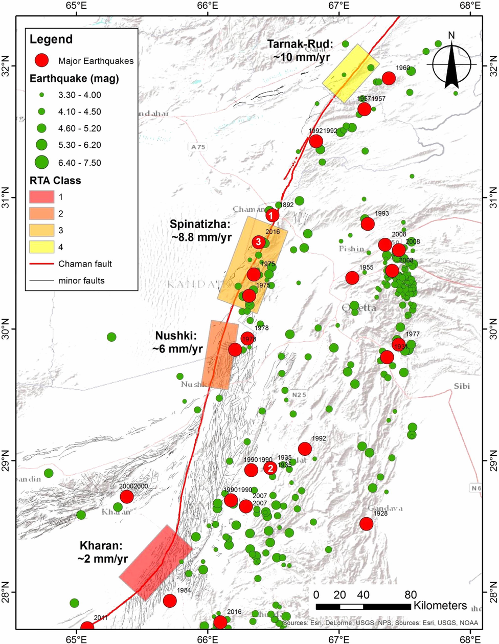 | Figure 1. Map showing historical earthquakes along the Chaman Fault. (1) Mw7 1892 along the Chaman Fault proper, (2) Mw7.7 1935 earthquake close to the town of Nushki, and (3) May 13, 2016 Mw5.5 earthquake in Qila Abdullah. Study areas are colored according to Relative Tectonic Activity (RTA) classes derived from geomorphology indexes, wind/water gaps, and river offset. This is contradictory to the observed velocity using GPS and InSAR techniques, which may suggest that the northern segments of the Chaman Fault system have only recently (∼100,000 years) become active. Source for earthquake data, USGS Earthquakes Hazard Program (Source: Crupa et al., 2017) |
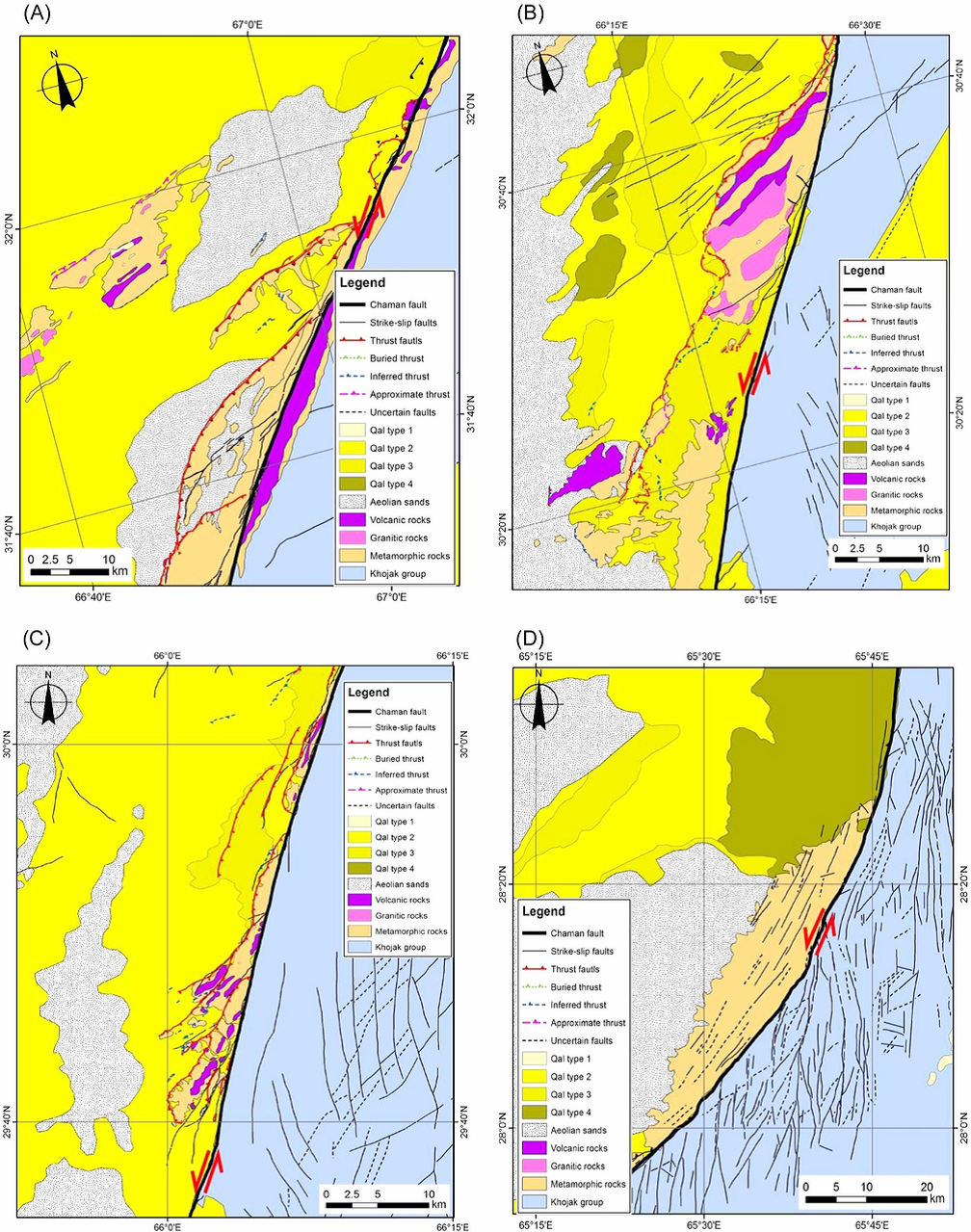 | Figure 2. Geologic maps generated from remote sensing images and previously published papers. (A) Map of Tarnark-Run Area, (B) Geological map of Spinatizha area, (C) Geological map over the Nushki areas, (D) Geological map of the Kharan area (Source: Crupa et al., 2017) |
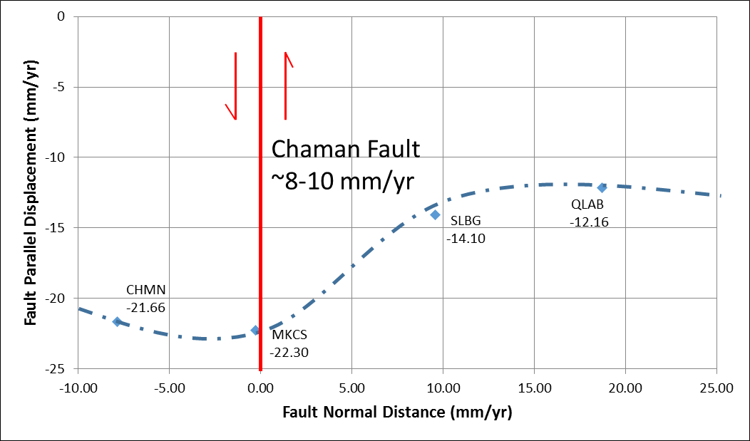 | Figure 3. Plot showing displacement along Chaman Fault, measured using GPS data (Source Crupa et al., 2017). |
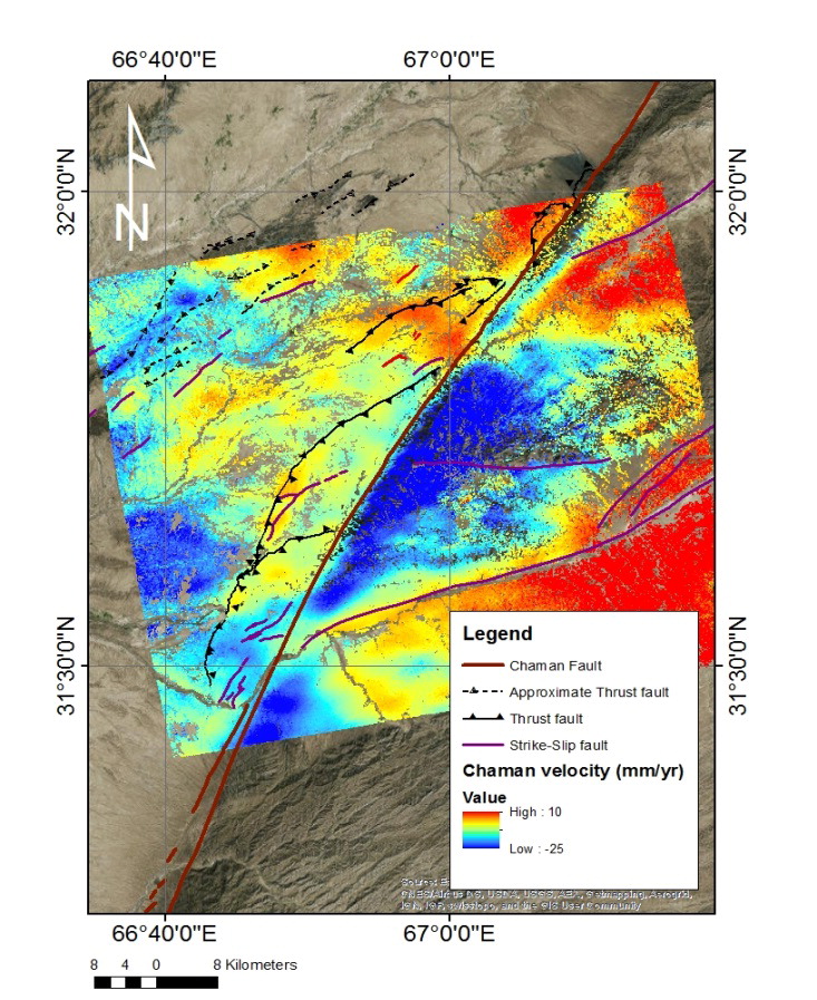 | Figure 4. InSAR images processed over the Tarnak-Rud area using 15 ALOS PALSAR images from December 24, 2006 to February 19, 2011. The image clearly shows left-lateral strike-slip motion along the mapped Chaman Fault showing s ∼10 mm/yr displacement between the left and right sides of the fault (Source: Crupa et al., 2017) |
Bibliography Crupa, W.E., Khan, S.D., Huang, J., Khan, A.S., Kasi, A., 2017. Active tectonic deformation of the Western Indian Plate Boundary: A case study from the Chaman Fault System, Journal of Asian Earth Sciences (2017), 147, 452-468; doi: http://dx.doi.org/10.1016/j.jseaes.2017.08.006 USGS Earthquakes Hazard Program. Earthquakes.usgs.gov.
|


